Amboyna Cay, Rifleman Bank, Barque Canada Reef, Spratly Islands
Rifleman Bank is a set of reefs that are submerged, but have multiple, permanent infrastructure elements to land helicoptors.
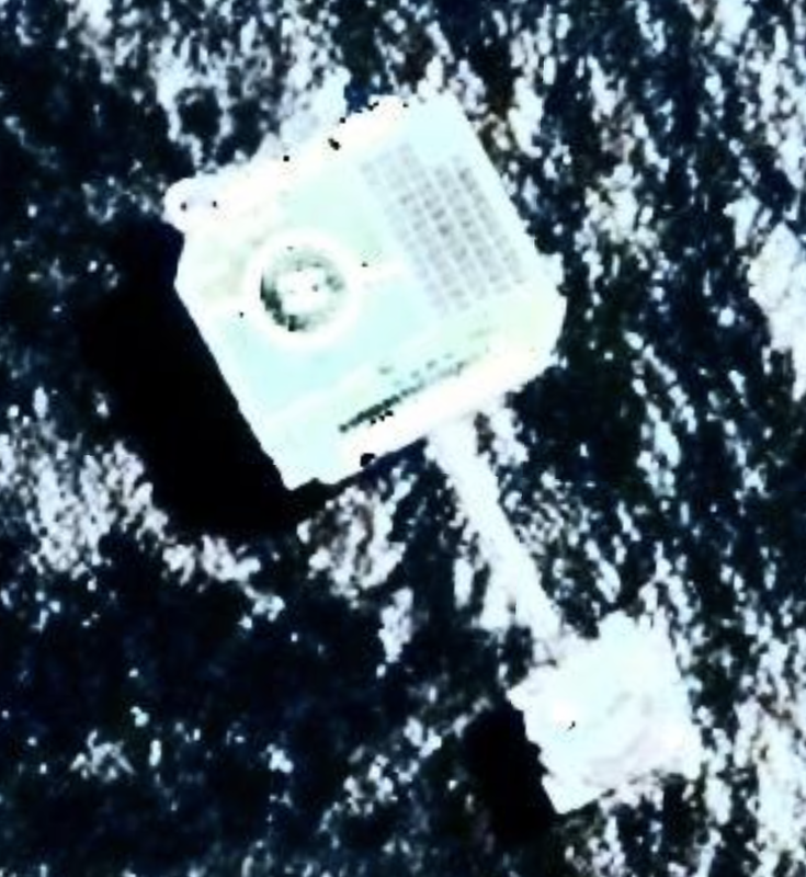
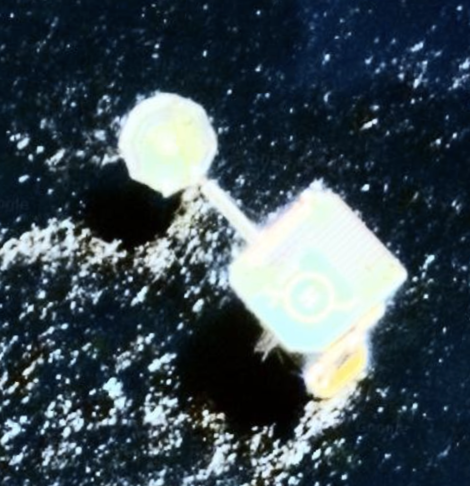
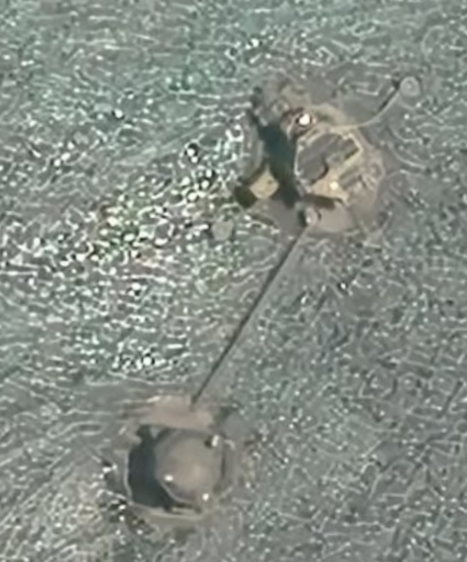
At the Southwestern tip of Rifleman Bank we see a pair of infrastructure connected by a bridge. Location: 7°32'02"N 111°32’57”E. One looks like a helipad. Date of satellite photo: May 1, 2018. North of that location at the top of the reef, we see another pair of infrastructure, and at the time there was a ship just south of this location 7°52'30"N 111°44’41"E. We have a third pair of infrastructure in the middle and on the east side of the reef.
Location: 7°42'11"N 111°45’08"E.
I wonder who is installing these dual pods in the water?
|
|
Grainger Bank
Just East of Alexandra Bank we see Grainger Bank, a.k.a., Qua Duong (Vietnamese) which is not visible in Google Earth, but there is a picture of an oil / gas rig in the description in Google Earth. According to a news article in e.vnexpress.net, Vietnam is building a series of rigs around Vanguard, Alexandra and Grainger banks and conducting oil and gas exploration activities. Vietnam claims this area as being within its exclusive economic zone (EEZ), and is also claimed by the PRC.
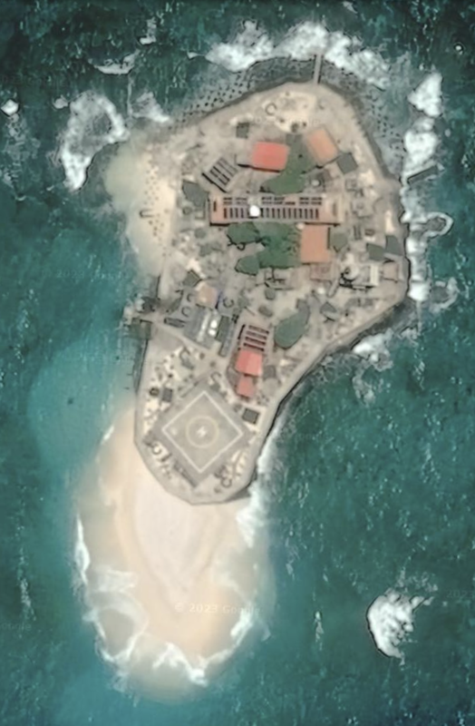
Satellite imagery: 05/1/2020. The buildings have rectangles on the roof, which are either solar panels or open roofs. Poor focus on this image. Location: 7°53'29"N 112°55'16"E. Length of the development is 0.1 miles, and including the sandy bit to the South, 0.14 miles. This is a very small island that looks to have a about 15 buildings atop each other. It almost looks deserted to us.
This island is located 262 miles from Miri, Malaysia.
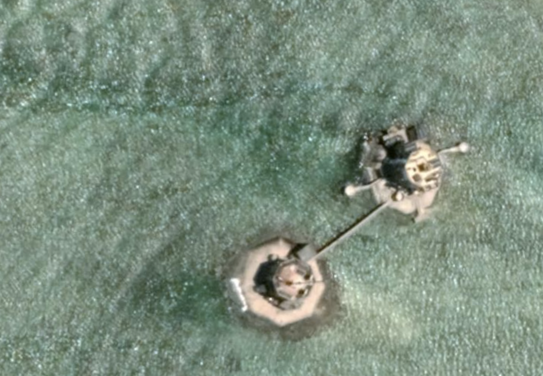
Barque Canada Reef has a pair of infrastructure and a ship at the northern end, and a slightly cleared path through the coral reef out to sea. 5/12/2020 photo. Location: 8°16'06"N 113°21'26"E. Two more infrastructure found. The northern tip at location 8°04'34"N 113°13’37"E. The middle, west side, near a channel through the reef. Location: 8°09'12"N 113°17’01”E. Date 4/5/2019.
According to Radio Free Asia, here, this reef will look vastly different as there has been a large land reclamation effort underway.

|
|
Name 1
Nearest Land
Distance from Land (miles)
Location (latitude & longitude)
Diameter (miles)
Date of Satellite Imagery
Airport Present?
Helipad Present?
Port / Dock Facility Present?
Buildings Present?
Defensive Infrastructure Present?
Athletic Facilities Present?
Hospital Present?
Sand Only Island?
Dredging Infrastructure Only?
Spratly Islands
Amboyna Cay
Malaysia
262
7°53'29"N 112°55'16"E
0.1
5/1/2020
No
Yes
Yes (small)
Yes
Not sure
No
No
No
No
Consulting Session for one hour
This is a one-hour meeting, remote or in-person, with Jeffrey Cohen, President of U.S. Advanced Computing Infrastructure, Inc.
- You choose the topic and deliverables.
- You may buy multiple hours to fund a project.
We believe management consulting is pursuing "the art of the possible." These are areas where we believe we may be helpful:
- We will discuss our research into the South China Sea
- We offer traditional IT management consulting services.
- We offer quantum computing consulting
- We offer financial investment analysis of stock portfolios based on our Chicago Quantum Net Score (read more in our published research). Today we run a model that analyzes ~3,000 U.S. listed equities and optimizes both 'long' and 'short' stock portfolios.
- Project and program management.
- Outsourcing advisory.
- We run your business problem on our discrete mathematical models (on our own server equipment using our own solvers).
- We may configure and run your problem on quantum annealing computers from D-Wave Systems Inc.
- We ALWAYS work confidentially, diligently, free of conflict of interest, and bring our best thinking and insights.
We can operate at both the strategic and tactical level depending on client need. This includes business strategy, business problem decomposition, mathematical and data design, algorithm design, and use of quantum and classical solvers. The President has a strategic perspective from ~ 30 years of executive corporate management in IT and professional services, and also rolls up his sleeves and codes when there is a good fit with the problem and his expertise.
Absolute discretion and professionalism is assured.
In closing
If you would prefer to discuss this 1:1 and negotiate a scope of work and level of effort, please contact us at [email protected] or call (312) 515-7333. We will develop a quotation and will invoice for our services.