Chicago Quantum
  • Home
    • About Us & What We Do
    • Our Capabilities
    • Brochure
    • Positions
  • Projects
    • Quantum Computing >
      • Quantum Computing - What is it?
      • Investing in Quantum Computing Stocks
      • Early Use Cases for Quantum Computing (2019 & 2020)
      • Early Use Case - Detail
      • 2020 Quantum Computing Ecosystem
      • Platforms Detail
      • 2024 Quantum Computing - What we are seeing
      • PQC Post Quantum Cryptography
    • South China Sea >
      • Nearshore Islands >
        • Swallow Reef and multiple reefs near Malaysia
        • Louisa Reef, Brunei
        • Basco and Mavudis Islands, Batanes, Philippines
        • Scarborough Shoal and Second Thomas Shoal, Philippines
        • Laut Island, Indonesia
        • Natuna Island, Indonesia
        • Dao Bach Long, Vietnam, Gulf of Tonkin
        • Koh Paulo Wai, and related islands in Kien Giang Province, Vietnam, Gulf of Thailand
        • Con Dao and Vanguard Bank, Vietnam
        • Long Hai, Vietnam
        • Qizhou Liedao & Nanshi, Hainan, China
        • Dongsha, Pratas Islands, Republic of China
        • Penghu County, Republic of China
        • Kinmen County Islands, Republic of China
        • Southern South China Sea
        • Mengalum, Pulau Tiga and Kampong Mantanani , Malaysia
        • Strategic underwater reef of the coast of mainland China
      • Spratly Islands >
        • Subi Reef, China, Spratly Islands
        • Mischief Reef, Spratly Islands
        • Fiery Cross Reef, Yongshu Jiao, China, Spratly Islands
        • Thitu Island, Pag-asa, Kalayaan, Spratly Islands
        • Taiping Island, Spratly Islands
        • Spratly Island and Ladd Reef Vietnam, Spratly Islands
        • North Danger Reef & Trident Shoal, Spratly Islands
        • Irving Reef, West York and Loaita Bank, Spratly Islands
        • Sand Cay, Namyit Island, and Gaven Reef, Tizard Bank, and Great Discovery Reef, Spratly Islands
        • Union Bank, Johnson South Reef, Sin Cowe, Hughes Reef, Whitsun Reef, Spratly Islands
        • Nanshan Island, Flat Island, Iroquois Reef, Jackson Atoll, Spratly Islands
        • Sabina Shoal, Second Thomas Shoal to Half Moon Shoal, West of Palawan, Spratly Islands
        • Amboyna Cay, Rifleman Bank, Barque Canada Reef, Vietnam
        • Erica Reef, Mariveles Reef, Investigator Island and Viper North, Spratly Islands
        • Pearson, Alison, Cornwallis, and Pigeon Reef, Vietnam Occupied
        • Luconia Breakers, Brunei and Malaysia Coast, Spratly Islands
        • London Reefs, Vietnam and Cuarteron Reef a.k.a. Huayang Island, China, Spratly Islands
      • Paracel Islands, China, PRC Overview, South China Sea >
        • Woody Island and Rocky Island, China, Paracel Islands
        • Triton Island, Zhongjian Dao, China, Paracel Islands
        • North Reef, NW Paracel Islands
        • Tree Island, West Sand, North, Middle, South Islands, and the Three Sisters, Xuande Islands, Amphitrite Group, Paracel Islands
        • Lincoln Island, Bombay Reef and Vuladore Reef, Paracel Islands
        • Duncan, Drummond, Pattle, Money and Antelope islands, Crescent Group, Paracel Islands
      • Participant List
      • Active Conflict Areas
      • Energy Transportation, Resources & Production
      • ROC - Taiwan Environment
    • Yellow Sea Construction
    • Iran Overview >
      • Iranian Energy Export Capabilities
      • Iranian Energy Production Capabilities
      • Iranian Energy Refining Capabilities
      • Iranian Importation of Afghan Opium in 2024
  • Advisory
    • Separately Managed Accounts
    • Pharmacy Retail Trends 2024
    • US Residential Real Estate Economic Analysis
  • Insights

Mengalum, Pulau Tiga and Kampong Mantanani , Malaysia

Updated August 19, 2024
​We see three islands west of eastern Malaysia. These three island groups run in an 89 mile long chain and hug the coast. Here is an image of those three islands. 

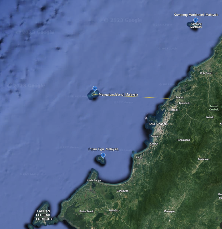
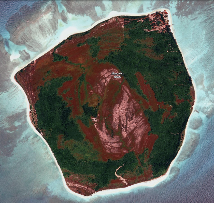
Mengalum Island is approximately 38.5 miles off the coast of Malaysia, due west of Tuaran and Tamparuli. It has a significant road network across the center of the island. This island is 1.85 miles long, and we see the outline of roads across the island that show from color variations in the imagery. It sits atop a reef. This is one of three sets of islands just West off the coast of the Eastern portion of Malaysia, and is well south of Borneo. We read this is a popular tourist destination.

In the satellite imagery we cannot see any man-made structures and the coloration is red, green and pink. We do see roads across the center. Location 6°12'09"N 115°35'03"E. We do not have a date for the satellite imagery.
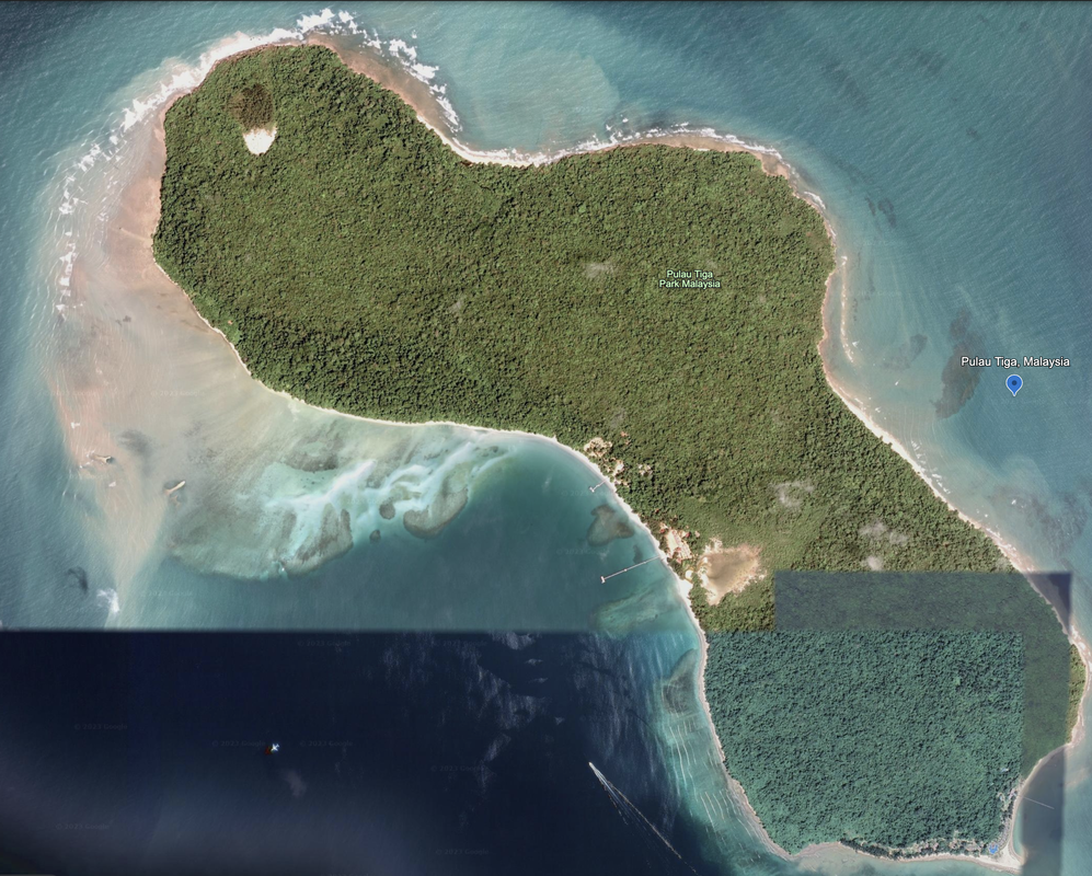
​
Picture
Mangalum Island looks very similar when viewing it via Copernicus Browser, Sentinel-2 L2A in True Color on 7/21/2024. The center of the island is deforested and bisected by a road. 7/31/2024 has too much cloud cover, so we went back 10 days.

Picture
Mangalum Island, Malaysia. A popular tourist island. April 26, 2024 Google Earth imagery.
Pulau Tiga, Malaysia

​Due south of Mangalum Island is Pulau Tiga, Malaysia, and appears in the satellite imagery to be fully natural with full coverage in green and limited manmade development. We do see three docks, housing developments and buildings near them on the South-central and Southeast sides of the island. Those look like great locations for houses, and must be for the very affluent, or for the well funded hotel resort. In more recent photos, the pictures of homes and possible resorts is even more clear. We see no defensive fortifications.


We note that Northwest of the island is undergoing significant reclamation, and we see the island’s potential for growth. Date of satellite imagery is unknown. Location: 5°42'17"N 115°40’16”E. Length is 3.24 miles.
Picture
Pulau Tiga, Malaysia. Better imagery of the development on the island. Google Earth, August 19, 2024 but no date provided (multiple sources).
Pulau Kalampunian, Malaysia (new development)
​Just northeast we find a new island, mostly sand, that looks like it is under development. A long, thin island that will likely grow on both ends. Google Earth imagery is from 5-1-2024, and we see the name Pulau Kalampunian. As we zoom out more, we see three points of development, one Northwest and one Northeast (older with a jetty), with possible reclamation equipment in the water.

The main island measures 0.51 miles long.

​
Picture
Picture
Kampong, Mantanani, Malaysia

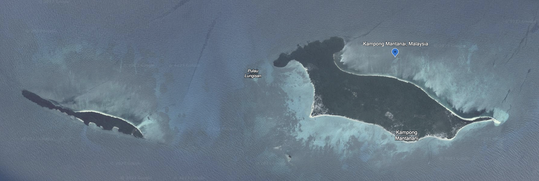
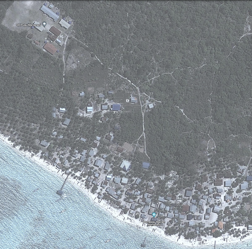
​Northeast of Mangalum Island is Kampong Mantanani, which has two adjacent islands marked as Pulau Mantanani Kecil and Pulau Lungisan. Location: 6°43'16"N 116°20’07”E. The length of the primary island is 2.3 miles. This island has two peers on the South side of the island, and some visible man-made development of buildings and roads. There is a 'lovely' beach club, significant housing by the water on the south, and along the north what looks like a construction or development site where the forest is cleared, there is solar power, and a number of storage huts or buildings. Date of Google Earth imagery: 10/29/2023.
Picture
Pulau Mantanani Kecil center of the island. Google Earth 10/29/2023 - small outpost with a control tower, helicopter pad and buildings along a rough jetty.
Picture
Overview of Kampong and Pulau Mantanani islands, Google Earth
Picture
Kampong Mantanani, Malaysia 10/29/2023 Google Earth imagery.
We got lucky with a photo of Pulau Point, Malaysia.
Posted by Pok Rie, it is beautiful and detailed. It was taken on August 23, 2020 and is shared on Pexel.
Picture
https://www.pexels.com/photo/aerial-view-of-buildings-in-an-island-10541852/, taken by Pok Rie in 2020. Note the signage in the grass that spells out Pulau Poin(t), which is in Malaysia.
Area
Name 1
Nearest Land
Distance from Land (miles)
Location (latitude & longitude)
Diameter (miles)
Date of Satellite Imagery
Airport Present?
Helipad Present?
Port / Dock Facility Present?
Buildings Present?
Defensive Infrastructure Present?
Athletic Facilities Present?
Hospital Present?
Sand Only Island?
Dredging Infrastructure Only?


Southern South China Sea
Mengalum Island
Malaysia
38.5
6°12'09"N 115°35'03"E
1.9
Unknown
No
No
Yes
Yes
No
No
No
No
No


Southern South China Sea
Pulau Tiga
Malaysia
6.8
5°42'17"N 115°40’16”E
3.24
Unknown
No
No
Yes
Yes
No
No
No
No
No


Southern South China Sea
Kampong Mantanani
Malaysia
14.6
6°43'16"N 116°20’07”E.
2.3
5/20/2009
No
No
No
No
No
No
No
No
No

Copyright 2024 & 2025 US Advanced Computing Infrastructure, Inc., Chicago Quantum (SM)
833 Central Avenue #1292, Highland Park, Illinois 60035-7292
​+1.312.515.7333

  • Home
    • About Us & What We Do
    • Our Capabilities
    • Brochure
    • Positions
  • Projects
    • Quantum Computing >
      • Quantum Computing - What is it?
      • Investing in Quantum Computing Stocks
      • Early Use Cases for Quantum Computing (2019 & 2020)
      • Early Use Case - Detail
      • 2020 Quantum Computing Ecosystem
      • Platforms Detail
      • 2024 Quantum Computing - What we are seeing
      • PQC Post Quantum Cryptography
    • South China Sea >
      • Nearshore Islands >
        • Swallow Reef and multiple reefs near Malaysia
        • Louisa Reef, Brunei
        • Basco and Mavudis Islands, Batanes, Philippines
        • Scarborough Shoal and Second Thomas Shoal, Philippines
        • Laut Island, Indonesia
        • Natuna Island, Indonesia
        • Dao Bach Long, Vietnam, Gulf of Tonkin
        • Koh Paulo Wai, and related islands in Kien Giang Province, Vietnam, Gulf of Thailand
        • Con Dao and Vanguard Bank, Vietnam
        • Long Hai, Vietnam
        • Qizhou Liedao & Nanshi, Hainan, China
        • Dongsha, Pratas Islands, Republic of China
        • Penghu County, Republic of China
        • Kinmen County Islands, Republic of China
        • Southern South China Sea
        • Mengalum, Pulau Tiga and Kampong Mantanani , Malaysia
        • Strategic underwater reef of the coast of mainland China
      • Spratly Islands >
        • Subi Reef, China, Spratly Islands
        • Mischief Reef, Spratly Islands
        • Fiery Cross Reef, Yongshu Jiao, China, Spratly Islands
        • Thitu Island, Pag-asa, Kalayaan, Spratly Islands
        • Taiping Island, Spratly Islands
        • Spratly Island and Ladd Reef Vietnam, Spratly Islands
        • North Danger Reef & Trident Shoal, Spratly Islands
        • Irving Reef, West York and Loaita Bank, Spratly Islands
        • Sand Cay, Namyit Island, and Gaven Reef, Tizard Bank, and Great Discovery Reef, Spratly Islands
        • Union Bank, Johnson South Reef, Sin Cowe, Hughes Reef, Whitsun Reef, Spratly Islands
        • Nanshan Island, Flat Island, Iroquois Reef, Jackson Atoll, Spratly Islands
        • Sabina Shoal, Second Thomas Shoal to Half Moon Shoal, West of Palawan, Spratly Islands
        • Amboyna Cay, Rifleman Bank, Barque Canada Reef, Vietnam
        • Erica Reef, Mariveles Reef, Investigator Island and Viper North, Spratly Islands
        • Pearson, Alison, Cornwallis, and Pigeon Reef, Vietnam Occupied
        • Luconia Breakers, Brunei and Malaysia Coast, Spratly Islands
        • London Reefs, Vietnam and Cuarteron Reef a.k.a. Huayang Island, China, Spratly Islands
      • Paracel Islands, China, PRC Overview, South China Sea >
        • Woody Island and Rocky Island, China, Paracel Islands
        • Triton Island, Zhongjian Dao, China, Paracel Islands
        • North Reef, NW Paracel Islands
        • Tree Island, West Sand, North, Middle, South Islands, and the Three Sisters, Xuande Islands, Amphitrite Group, Paracel Islands
        • Lincoln Island, Bombay Reef and Vuladore Reef, Paracel Islands
        • Duncan, Drummond, Pattle, Money and Antelope islands, Crescent Group, Paracel Islands
      • Participant List
      • Active Conflict Areas
      • Energy Transportation, Resources & Production
      • ROC - Taiwan Environment
    • Yellow Sea Construction
    • Iran Overview >
      • Iranian Energy Export Capabilities
      • Iranian Energy Production Capabilities
      • Iranian Energy Refining Capabilities
      • Iranian Importation of Afghan Opium in 2024
  • Advisory
    • Separately Managed Accounts
    • Pharmacy Retail Trends 2024
    • US Residential Real Estate Economic Analysis
  • Insights