Chicago Quantum
  • Home
    • About Us & What We Do
    • Our Capabilities
    • Brochure
    • Positions
  • Projects
    • Quantum Computing >
      • Quantum Computing - What is it?
      • Investing in Quantum Computing Stocks
      • Early Use Cases for Quantum Computing (2019 & 2020)
      • Early Use Case - Detail
      • 2020 Quantum Computing Ecosystem
      • Platforms Detail
      • 2024 Quantum Computing - What we are seeing
      • PQC Post Quantum Cryptography
    • South China Sea >
      • Nearshore Islands >
        • Swallow Reef and multiple reefs near Malaysia
        • Louisa Reef, Brunei
        • Basco and Mavudis Islands, Batanes, Philippines
        • Scarborough Shoal and Second Thomas Shoal, Philippines
        • Laut Island, Indonesia
        • Natuna Island, Indonesia
        • Dao Bach Long, Vietnam, Gulf of Tonkin
        • Koh Paulo Wai, and related islands in Kien Giang Province, Vietnam, Gulf of Thailand
        • Con Dao and Vanguard Bank, Vietnam
        • Long Hai, Vietnam
        • Qizhou Liedao & Nanshi, Hainan, China
        • Dongsha, Pratas Islands, Republic of China
        • Penghu County, Republic of China
        • Kinmen County Islands, Republic of China
        • Southern South China Sea
        • Mengalum, Pulau Tiga and Kampong Mantanani , Malaysia
        • Strategic underwater reef of the coast of mainland China
      • Spratly Islands >
        • Subi Reef, China, Spratly Islands
        • Mischief Reef, Spratly Islands
        • Fiery Cross Reef, Yongshu Jiao, China, Spratly Islands
        • Thitu Island, Pag-asa, Kalayaan, Spratly Islands
        • Taiping Island, Spratly Islands
        • Spratly Island and Ladd Reef Vietnam, Spratly Islands
        • North Danger Reef & Trident Shoal, Spratly Islands
        • Irving Reef, West York and Loaita Bank, Spratly Islands
        • Sand Cay, Namyit Island, and Gaven Reef, Tizard Bank, and Great Discovery Reef, Spratly Islands
        • Union Bank, Johnson South Reef, Sin Cowe, Hughes Reef, Whitsun Reef, Spratly Islands
        • Nanshan Island, Flat Island, Iroquois Reef, Jackson Atoll, Spratly Islands
        • Sabina Shoal, Second Thomas Shoal to Half Moon Shoal, West of Palawan, Spratly Islands
        • Amboyna Cay, Rifleman Bank, Barque Canada Reef, Vietnam
        • Erica Reef, Mariveles Reef, Investigator Island and Viper North, Spratly Islands
        • Pearson, Alison, Cornwallis, and Pigeon Reef, Vietnam Occupied
        • Luconia Breakers, Brunei and Malaysia Coast, Spratly Islands
        • London Reefs, Vietnam and Cuarteron Reef a.k.a. Huayang Island, China, Spratly Islands
      • Paracel Islands, China, PRC Overview, South China Sea >
        • Woody Island and Rocky Island, China, Paracel Islands
        • Triton Island, Zhongjian Dao, China, Paracel Islands
        • North Reef, NW Paracel Islands
        • Tree Island, West Sand, North, Middle, South Islands, and the Three Sisters, Xuande Islands, Amphitrite Group, Paracel Islands
        • Lincoln Island, Bombay Reef and Vuladore Reef, Paracel Islands
        • Duncan, Drummond, Pattle, Money and Antelope islands, Crescent Group, Paracel Islands
      • Participant List
      • Active Conflict Areas
      • Energy Transportation, Resources & Production
      • ROC - Taiwan Environment
    • Yellow Sea Construction
    • Iran Overview >
      • Iranian Energy Export Capabilities
      • Iranian Energy Production Capabilities
      • Iranian Energy Refining Capabilities
      • Iranian Importation of Afghan Opium in 2024
  • Advisory
    • Separately Managed Accounts
    • Pharmacy Retail Trends 2024
    • US Residential Real Estate Economic Analysis
  • Insights

Mischief Reef, Spratly Islands

Update May 31, 2025

Google Earth imagery is from 2016, but Copernicus Browser, Sentinel-2 has current imagery, although low resolution.

We see Mischief Reef with its mature development on the island, and the small island of Mei Jinan on the south-central rim. There is no visible development, but in the False Color photo (the one in red) we see significant numbers of ships in the protected bay in the Northeast corner. Like other formations, we notice the Chinese are not investing in these islands with additional reclamation or large-scale military construction (e.g., airfields, buildings, ports) but we are seeing them being used to support their fishing and day-to-day operational tasks. Maybe 2025 is a 'harvest the benefits' year in the South China Sea.

Mischief Reef is one of three PRC militarized islands that forms an equilateral triangle, about 120 miles per side, with Mischief Reef at the SE corner, Subi Reef at the North corner, and Fiery Cross Reef at the SW corner.
Picture
Sentinel-2 L2A True Color, 500m resolution, May 26, 2025.
Picture
Copernicus Browser, Sentinel-2 L2A False Color 300m 04-29-2025 Mischief Reef
Updated August 26, 2024 with Sentinel-2 imagery.
​Mischief Reef is an advanced military island developed and occupied by the People's Republic of China (PRC).

​Mischief Reef, a.k.a. Panganiban Reef in Tagalog, Đá Vành Khăn in Vietnamese, and Meiji Jiao, which translates to Meiji Reef, according to 
Wikipedia, and is located at 9°55′N 115°32′E. It consists of a large lagoon and rocks that lie above water at low tide.
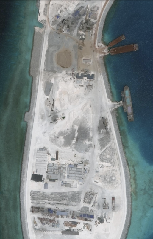
 Google Earth imagery is from May 1, 2016, and is obsolete. Island diameter from east to west: 5.45 miles. Current development incorporates about 55% of the circumference of the reef. There is room to grow, and some infrastructure already exists on the southern end. This reef structure is more contiguous and we see two navigation channels into the fully enclosed lagoon.  Another location snapshot: ​9°55'00"N 115°33'08"E.

It changed hands as a natural atoll around January 1995, when it went from being part of the Kalayaan Islands municipality of Palawan to the active jurisdiction of Nansha Islands, Sansha City, Hainan, China. One day, PRC built fishing huts, sailed in a few ships, and flew their flag on the reef. When the Philippines fisherman found them, little was done, and the PRC started land reclamation in earnest. By 2016, or 21 years later, the PRC created a large artificial island on the atoll and had the bare-bones structure of a modern military island.  We cannot wait to analyze the island with newer satellite imagery. It looks to be constructed to support marines and both naval and aviation operations.

Mischief Reef is a large and significant land reclamation effort. The diameter of the Reef is 5.6 miles, and since the reclaimed land is more than 50% of the circumference of the coral atoll, the reclamation is more than 5.6 miles long, and as wide as the island needed to be. The reclamation we see covers more than half of the outer rim (the Northern half).  We see calm waters inside the reef and two well defined and apparently deep entry/exit points through the coral reef. This reef is shaped like a hollow circle, and it looks like the Northern ~60% of the circle are reclaimed. There is infrastructure on the southern half that would allow for further reclamation, but it appears the focus was on densely packing into the 2016 footprint.

This is similar to the shape of Subi Reef, where the center of the atoll is water.
​

Mischief reef is in the eastern Spratly islands, 146.8 miles west of Palawan Island and 490.7 miles SW of Manila. This development is due East of Union Banks, and 19.9 miles west of Second Thomas Shoal, where the Philippines has run a ship aground to claim the reef, but has done nothing to build an island. 

​
This patch of the Spratly Islands is relatively undeveloped, and most reefs are underwater, undeveloped, and non-military. We believe Mischief Reef changes the game as it is being developed into a significant military installation for the PLAAF and the PLAN in the middle of civilian or natural reefs.

Again, this Northeastern portion of the Spratlys, the islands closest to the Philippines, which are empty. As we move more southwest, closer to Brunei and Malaysia, there is slightly more development by Malaysia. This is a major and potentially strategic difference, and makes Mischief Reef a strategic outpost, close to the Philippines.
​
Picture
Mischief Reef, Google Earth 5/1/2016 of the full island. This photo is approximately 8 years old, and is taken from 11,824m, -9m. Scale is 1,000 meters per unit measure.

Picture
Mischief Reef, 7/31/2024, False Color, Copernicus Sentinel-2 L2A. Notice the line between extending from the NW corner into the reef (new) and the concentration of ships (also new) from April 2024.
Picture
Mischief Reef, True Color, Sentinel-2, L2A, 7/31/2024 satellite imagery from Copernicus Browser, eESA. Notice the completion of many of the land tracts vs. 2016, and the NW interior corner with pipes.
In the most recent imagery from 7/31/2024, we can see a dredging operation underway in the NW corner in the interior of the atoll, and a large formation of large ships and structures inside the atoll on the east side. These two features are new vs satellite imagery as recently as 4/22/2024.
In the Google Earth satellite photo we are using, and in more recent ones from Sentinel-2, there are many ships inside the lagoon. These are not permanently anchored and are 100% different from April to July 2024.

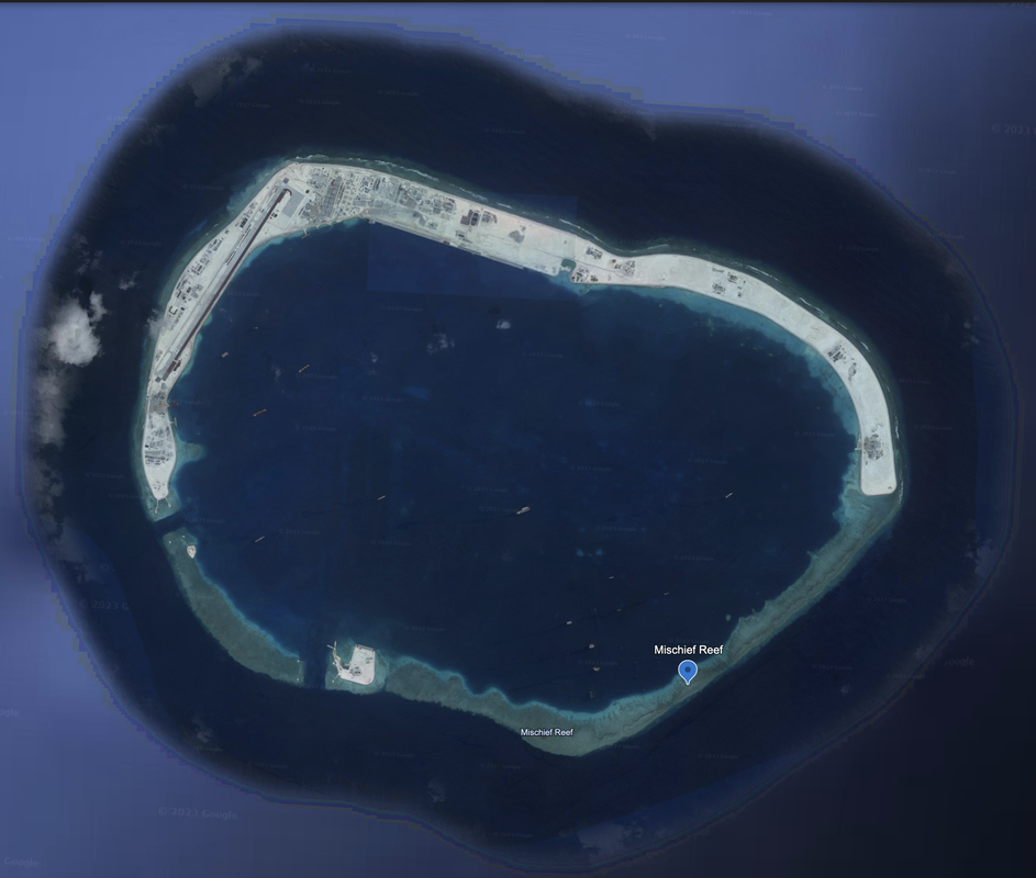
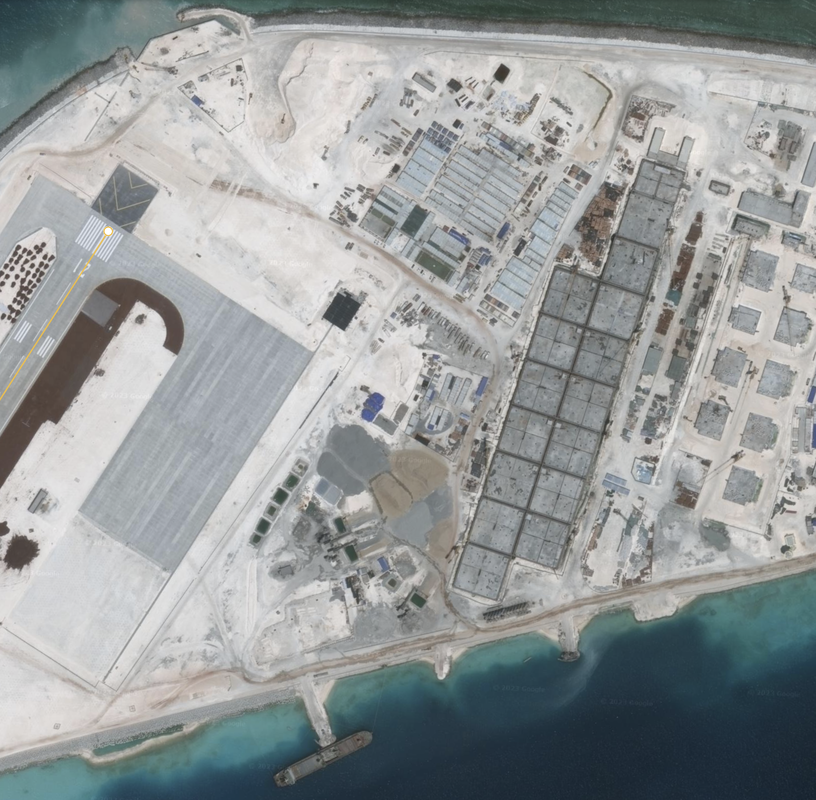
We see a large airport (1.67 miles long) and airfield.  The airport runway is laid out on the Northwest corner of the island.  South of the airfield we see significant construction equipment and effort underway. There are square buildings at the north end of the airfield, but those do not look like traditional hangers.

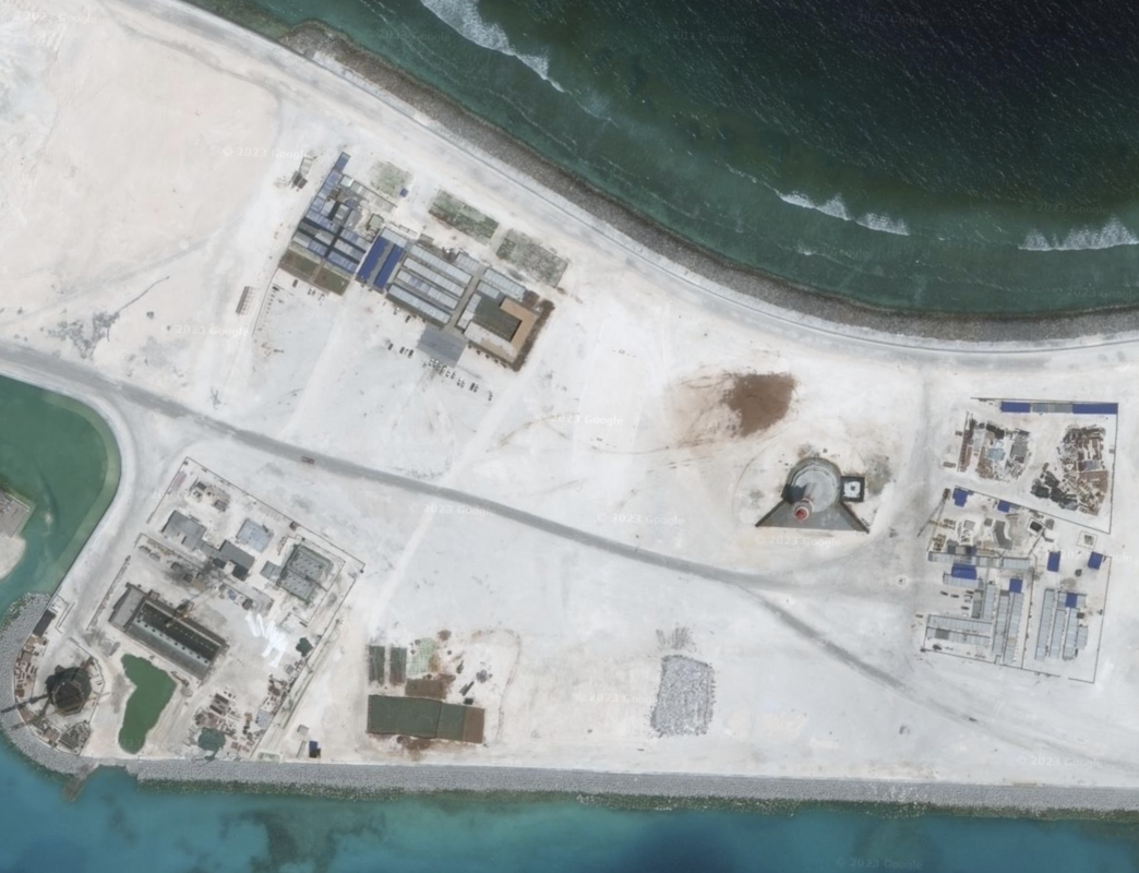
It looks like tank trap shapes that are put into the water to build up the sea wall (have not seen this before). We see silos, four at a time, and at least 8 sets of four, which we could guess are to make concrete or aggregate. There are ships and barges as well.

Similar to other PRC airfields we have observed, there is an area being built for airmen and staff, along with hospitals and recreation facilities. However, the reef development continues onward and although there are areas marked off, we cannot tell what will be placed there. Past the staffing areas, we see navigation and communication areas, and what looks like a rather large cannon pointed into the bay.
​
Supporting our island analysis, U.S. Senator David Purdue, on a Freedom of Navigation Operation saw "dozens of PLAN ships and supply ships at Mischief Reef."
This is a fully militarized island, according to U.S. Admiral John C. Aquilino, in a Reuters news interview given during a tour of the Spratly Islands in a U.S. Navy reconnaissance aircraft that flew near these features, and was published March 21, 2022. According to U.S. Admiral Aquilino, Subi Reef, Mischief Reef and Fiery Cross are fully militarized islands occupied by PRC China.
Mischief Reef is 20 miles away from Second Thomas Shoal, where the Philippines maintains an antique ship as a permanent base.

Picture
Picture
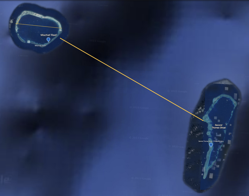
It is only 20 miles from Mischief Reef (PRC) to Second Thomas Shoal (PH), according to Google Earth 12/14/2015.
Picture
Picture
We have seen open source news sources with more recent imagery. It shows Mischief Reef as a bustling, modern, operational, and advanced military island with commentary that the airfield and local port facilities are already in operational use. From what I saw, it reminds me of a mix of Dubai and Las Vegas, whereas in 1995 there was only a few fishing structures on stilts.

Imagine the 29 year transformation to create an above sea-level island, build, garrison and outfit a joint operations facility.
PUB. 161 (ENROUTE) SAILING DIRECTIONS ★ ★
2020 SOUTH CHINA SEA AND THE GULF OF THAILAND (updated through November 2023)

​Prepared and published by the NATIONAL GEOSPATIAL-INTELLIGENCE AGENCY, Springfield, Virginia

What we know from the NGA Sailing Guide, page 13, is that there are three entrances to the lagoon, and two of them are boat channels. The lagoon has an average depth of about 26m, the SW part of the lagoon is free of dangers and the entrance is navigable if care is taken.

​The following warning is posted about Mischief Reef:
"Caution.—It was reported (1995) that the area within a 60 mile radius of Mischief Reef has been declared prohibited to all vessels."

Area
Name 1
Nearest Land
Distance from Land (miles)
Location (latitude & longitude)
Diameter (miles)
Date of Satellite Imagery
Airport Present?
Helipad Present?
Port / Dock Facility Present?
Buildings Present?
Defensive Infrastructure Present?
Athletic Facilities Present?
Hospital Present?
Sand Only Island?
Dredging Infrastructure Only?


Spratly Islands
Mischief Reef
Philippines
152
9°53'11"N 115°31’59”E
5.5
5/1/2016
Yes
No
Yes
Yes
Yes
Yes
Likely, but not sure
No
No

Copyright 2024 & 2025 US Advanced Computing Infrastructure, Inc., Chicago Quantum (SM)
833 Central Avenue #1292, Highland Park, Illinois 60035-7292
​+1.312.515.7333

  • Home
    • About Us & What We Do
    • Our Capabilities
    • Brochure
    • Positions
  • Projects
    • Quantum Computing >
      • Quantum Computing - What is it?
      • Investing in Quantum Computing Stocks
      • Early Use Cases for Quantum Computing (2019 & 2020)
      • Early Use Case - Detail
      • 2020 Quantum Computing Ecosystem
      • Platforms Detail
      • 2024 Quantum Computing - What we are seeing
      • PQC Post Quantum Cryptography
    • South China Sea >
      • Nearshore Islands >
        • Swallow Reef and multiple reefs near Malaysia
        • Louisa Reef, Brunei
        • Basco and Mavudis Islands, Batanes, Philippines
        • Scarborough Shoal and Second Thomas Shoal, Philippines
        • Laut Island, Indonesia
        • Natuna Island, Indonesia
        • Dao Bach Long, Vietnam, Gulf of Tonkin
        • Koh Paulo Wai, and related islands in Kien Giang Province, Vietnam, Gulf of Thailand
        • Con Dao and Vanguard Bank, Vietnam
        • Long Hai, Vietnam
        • Qizhou Liedao & Nanshi, Hainan, China
        • Dongsha, Pratas Islands, Republic of China
        • Penghu County, Republic of China
        • Kinmen County Islands, Republic of China
        • Southern South China Sea
        • Mengalum, Pulau Tiga and Kampong Mantanani , Malaysia
        • Strategic underwater reef of the coast of mainland China
      • Spratly Islands >
        • Subi Reef, China, Spratly Islands
        • Mischief Reef, Spratly Islands
        • Fiery Cross Reef, Yongshu Jiao, China, Spratly Islands
        • Thitu Island, Pag-asa, Kalayaan, Spratly Islands
        • Taiping Island, Spratly Islands
        • Spratly Island and Ladd Reef Vietnam, Spratly Islands
        • North Danger Reef & Trident Shoal, Spratly Islands
        • Irving Reef, West York and Loaita Bank, Spratly Islands
        • Sand Cay, Namyit Island, and Gaven Reef, Tizard Bank, and Great Discovery Reef, Spratly Islands
        • Union Bank, Johnson South Reef, Sin Cowe, Hughes Reef, Whitsun Reef, Spratly Islands
        • Nanshan Island, Flat Island, Iroquois Reef, Jackson Atoll, Spratly Islands
        • Sabina Shoal, Second Thomas Shoal to Half Moon Shoal, West of Palawan, Spratly Islands
        • Amboyna Cay, Rifleman Bank, Barque Canada Reef, Vietnam
        • Erica Reef, Mariveles Reef, Investigator Island and Viper North, Spratly Islands
        • Pearson, Alison, Cornwallis, and Pigeon Reef, Vietnam Occupied
        • Luconia Breakers, Brunei and Malaysia Coast, Spratly Islands
        • London Reefs, Vietnam and Cuarteron Reef a.k.a. Huayang Island, China, Spratly Islands
      • Paracel Islands, China, PRC Overview, South China Sea >
        • Woody Island and Rocky Island, China, Paracel Islands
        • Triton Island, Zhongjian Dao, China, Paracel Islands
        • North Reef, NW Paracel Islands
        • Tree Island, West Sand, North, Middle, South Islands, and the Three Sisters, Xuande Islands, Amphitrite Group, Paracel Islands
        • Lincoln Island, Bombay Reef and Vuladore Reef, Paracel Islands
        • Duncan, Drummond, Pattle, Money and Antelope islands, Crescent Group, Paracel Islands
      • Participant List
      • Active Conflict Areas
      • Energy Transportation, Resources & Production
      • ROC - Taiwan Environment
    • Yellow Sea Construction
    • Iran Overview >
      • Iranian Energy Export Capabilities
      • Iranian Energy Production Capabilities
      • Iranian Energy Refining Capabilities
      • Iranian Importation of Afghan Opium in 2024
  • Advisory
    • Separately Managed Accounts
    • Pharmacy Retail Trends 2024
    • US Residential Real Estate Economic Analysis
  • Insights