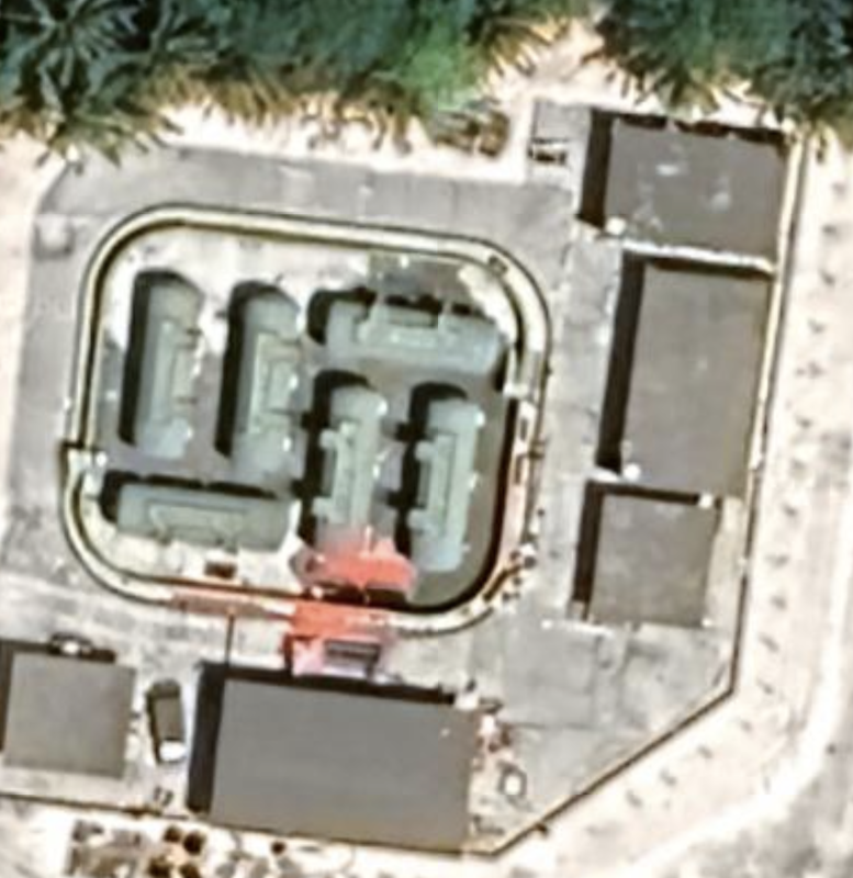
Taiping Island, Spratly Islands
It has a runway which is 0.75 miles long, and multiple buildings and defensive fortifications on the island. This is a green, lush island on a larger coral atoll with an east-west diameter of 1.47 miles, so there is room to expand through land reclamation.
This island is occupied and administered by the Republic of China (ROC) out of Kaohsiung City, Cijin District, Taiwan. It is in a crowded part of the Spratly Islands. Location: 10°22'49"N 114°21'32"E and the satellite imagery is from September 18, 2023. According to Wikipedia, it has 600 permanent residents and no civilians, so it is a government/military island. It also administers the small sand cay we call Tizard Bank 3, which is called Zhongzhou Reef, or Ban Than Reef.
Taiping Island, a.k.a., Itu Aba (common name in Malaysian meaning 'what's that?', Taiping Dao (very peaceful island), Widuabe (Hainanese fishermen), and Huangshanma Jiao and Huangshanma Zhi (Yellow Mountain Horse Underwea Mound) in Mandarin Chinese. In Vietnamese it is called Ba Binh, Dao Ba Binh meaning calm wave / sea island. In Tagalog it is Pulo ng Ligaw, or Island of Lost / Wild (thank you Wikipedia).
A note of history: During WWII, Japan occupied and garrisoned this island, built a submarine base, and the Republic of China established a permanent presence on the island in July 1956 (Source: Wikipedia).

It is occupied by Republic of China (ROC) military troops, according to Wikipedia.
Satellite imagery from 9/18/2023, and the location is 10.22.34N by 114.21.54E. We see a farm of solar panels, signs of defensive installations, and continued construction on the Western side of the island. This is an island with an airport and a protected bay and port facility The island appears to have small defensive fortifications around the island (cannon), and many interesting shapes to review. It is a combined sea and air serving island. We see solar panels and what appear to be shop items.
This island is mostly vegetation, with a airport runway running through the center of the island, and a small pair of protected bays for shipping and docks. We see a barge and boat in the bay. The runway is 0.75 miles long with a small parking area for planes on the East side of the island. We see fortifications on this island, or at least things that look like fortifications. We see round turrets around the runway.
We also see one building with signage. This island appears to have heavy anti-aircraft cannon fortifications, meaning gun emplacements around the airport and beach.
We do not see many barracks or housing structures beneath the trees, but assume they are there.
|

|
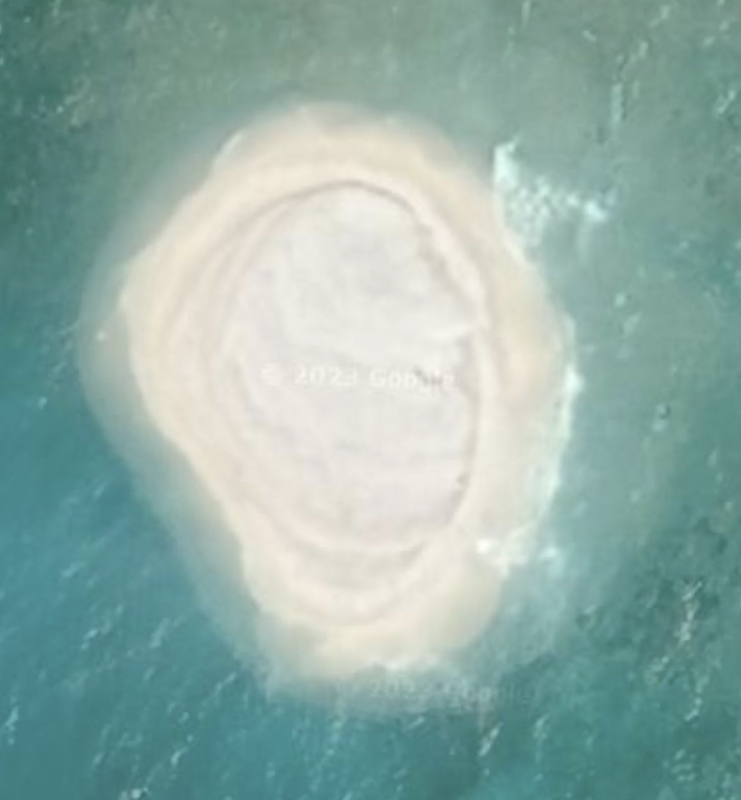
It is called Zhengzhou Reef / Ban Than Reef and is a mound of sand extending above sea level at location: 10°23'06"N 114°24’53”E. Satellite imagery dated 03/09/2021.
Name 1
Nearest Land
Distance from Land (miles)
Location (latitude & longitude)
Diameter (miles)
Date of Satellite Imagery
Airport Present?
Helipad Present?
Port / Dock Facility Present?
Buildings Present?
Defensive Infrastructure Present?
Athletic Facilities Present?
Hospital Present?
Sand Only Island?
Dredging Infrastructure Only?
Spratly Islands
Tizard Bank (6 islands)
Philippines and Vietnam
228 and 363
10°12'05"N 114°14’13
37.2
10/27/2023
No
Yes
Yes
Yes
Yes
No
No
Yes (on some)
No
Consulting Session for one hour
This is a one-hour meeting, remote or in-person, with Jeffrey Cohen, President of U.S. Advanced Computing Infrastructure, Inc.
- You choose the topic and deliverables.
- You may buy multiple hours to fund a project.
We believe management consulting is pursuing "the art of the possible." These are areas where we believe we may be helpful:
- We will discuss our research into the South China Sea
- We offer traditional IT management consulting services.
- We offer quantum computing consulting
- We offer financial investment analysis of stock portfolios based on our Chicago Quantum Net Score (read more in our published research). Today we run a model that analyzes ~3,000 U.S. listed equities and optimizes both 'long' and 'short' stock portfolios.
- Project and program management.
- Outsourcing advisory.
- We run your business problem on our discrete mathematical models (on our own server equipment using our own solvers).
- We may configure and run your problem on quantum annealing computers from D-Wave Systems Inc.
- We ALWAYS work confidentially, diligently, free of conflict of interest, and bring our best thinking and insights.
We can operate at both the strategic and tactical level depending on client need. This includes business strategy, business problem decomposition, mathematical and data design, algorithm design, and use of quantum and classical solvers. The President has a strategic perspective from ~ 30 years of executive corporate management in IT and professional services, and also rolls up his sleeves and codes when there is a good fit with the problem and his expertise.
Absolute discretion and professionalism is assured.
In closing
If you would prefer to discuss this 1:1 and negotiate a scope of work and level of effort, please contact us at [email protected] or call (312) 515-7333. We will develop a quotation and will invoice for our services.