Basco and Mavudis Islands, Batanes, Philippines
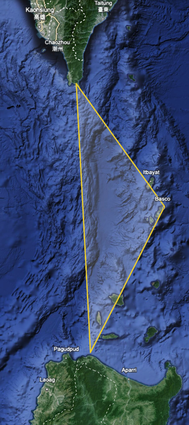
Batanes County is the northernmost point of the Philippines with a population of 18,000. It is a series of islands in the Bashi Channel, an access point into the South China Sea from the Western Pacific, and located approximately 125 miles from the main island of Taiwan.
We have read that the U.S. military is in talks to develop a civilian port in Batanes on the island of Basco, in collaboration with Japan, and that both would have availability to the port facilities. According to numerous news sources, negotiations between the U.S., Japan and the Philippines continue (as of February 2024).
According to a Newsweek article (Sep 7 2023 b Brendan Cole), talks are led by Batanes Governor Marilou Cayco to gain foreign funding to build a port to provide cargo ships a safe place during rough seas in monsoon season. Mayor Cayco is also seeking funding for a new airport from the U.S. military. The existing port facilities in Batanes are inaccessible during rough weather...that it is a "fair weather" port. The new port on Basco Island would be available year-round. Source: Reuters. That same article stated that there are 150,000 filipinos living in Taiwan, and this island port could provide an evacuation path if tensions rise and fighting breaks out.
During KAMANDAG 7, a recent military exercise, elements of the 31st Marine Expeditionary Unit (MEU) visited Batanes, and have visited at least two other times to liaise with local Philippine government and military teams. Source: U.S. Naval Institute article by Aaron-Matthew Lariose, January 8, 2024. The 31st MEU is a forward deployed force based in Okinawa, Japan.
Philippines President Ferdinand Marcos Jr. would be helpful in the event of a PRC invasion of ROC under the Enhanced Defence Cooperation Agreement between the US and the Philippines. This is following a 2023 decision by President Marcos Jr. to grant indefinite access to U.S. military forces to four Philippine military bases.
The more broad strategy between the U.S. and the Philippines was outlined in a 2023 US Department of Defence open source memorandum. It suggests significantly increased cooperation between the two countries, including investment in military bases and the development of a plan for the Philippines to acquire multi-role fighter jets.
The news source cited the PS-39 Facebook page, which we visited on February 26, 2024 (here). The BRP Conrado Yap was named after Captain Conrado Yap, a Philippine Army Officer and winner of the Medal of Valor for his actions fighting the Communist Chinese in the Republic of Korea. His last words were "Steady On."
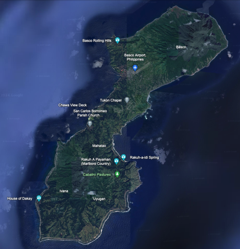
In satellite imagery by Google Earth partially updated as recently as 12/31/2023, we see Basco has an airport with a single 0.75 mile runway. The island is 11.7 miles in diameter. We do not see any port facilities except what looks like a local fishing and sport dock. Location: 20°20°28'09"N 121°53'39"E.
Consulting Session for one hour
This is a one-hour meeting, remote or in-person, with Jeffrey Cohen, President of U.S. Advanced Computing Infrastructure, Inc.
- You choose the topic and deliverables.
- You may buy multiple hours to fund a project.
We believe management consulting is pursuing "the art of the possible." These are areas where we believe we may be helpful:
- We will discuss our research into the South China Sea
- We offer traditional IT management consulting services.
- We offer quantum computing consulting
- We offer financial investment analysis of stock portfolios based on our Chicago Quantum Net Score (read more in our published research). Today we run a model that analyzes ~3,000 U.S. listed equities and optimizes both 'long' and 'short' stock portfolios.
- Project and program management.
- Outsourcing advisory.
- We run your business problem on our discrete mathematical models (on our own server equipment using our own solvers).
- We may configure and run your problem on quantum annealing computers from D-Wave Systems Inc.
- We ALWAYS work confidentially, diligently, free of conflict of interest, and bring our best thinking and insights.
We can operate at both the strategic and tactical level depending on client need. This includes business strategy, business problem decomposition, mathematical and data design, algorithm design, and use of quantum and classical solvers. The President has a strategic perspective from ~ 30 years of executive corporate management in IT and professional services, and also rolls up his sleeves and codes when there is a good fit with the problem and his expertise.
Absolute discretion and professionalism is assured.
In closing
If you would prefer to discuss this 1:1 and negotiate a scope of work and level of effort, please contact us at [email protected] or call (312) 515-7333. We will develop a quotation and will invoice for our services.