Chicago Quantum
  • Home
    • About Us & What We Do
    • Our Capabilities
    • Brochure
    • Positions
  • Projects
    • Quantum Computing >
      • Quantum Computing - What is it?
      • Investing in Quantum Computing Stocks
      • Early Use Cases for Quantum Computing (2019 & 2020)
      • Early Use Case - Detail
      • 2020 Quantum Computing Ecosystem
      • Platforms Detail
      • 2024 Quantum Computing - What we are seeing
      • PQC Post Quantum Cryptography
    • South China Sea >
      • Nearshore Islands >
        • Swallow Reef and multiple reefs near Malaysia
        • Louisa Reef, Brunei
        • Basco and Mavudis Islands, Batanes, Philippines
        • Scarborough Shoal and Second Thomas Shoal, Philippines
        • Laut Island, Indonesia
        • Natuna Island, Indonesia
        • Dao Bach Long, Vietnam, Gulf of Tonkin
        • Koh Paulo Wai, and related islands in Kien Giang Province, Vietnam, Gulf of Thailand
        • Con Dao and Vanguard Bank, Vietnam
        • Long Hai, Vietnam
        • Qizhou Liedao & Nanshi, Hainan, China
        • Dongsha, Pratas Islands, Republic of China
        • Penghu County, Republic of China
        • Kinmen County Islands, Republic of China
        • Southern South China Sea
        • Mengalum, Pulau Tiga and Kampong Mantanani , Malaysia
        • Strategic underwater reef of the coast of mainland China
      • Spratly Islands >
        • Subi Reef, China, Spratly Islands
        • Mischief Reef, Spratly Islands
        • Fiery Cross Reef, Yongshu Jiao, China, Spratly Islands
        • Thitu Island, Pag-asa, Kalayaan, Spratly Islands
        • Taiping Island, Spratly Islands
        • Spratly Island and Ladd Reef Vietnam, Spratly Islands
        • North Danger Reef & Trident Shoal, Spratly Islands
        • Irving Reef, West York and Loaita Bank, Spratly Islands
        • Sand Cay, Namyit Island, and Gaven Reef, Tizard Bank, and Great Discovery Reef, Spratly Islands
        • Union Bank, Johnson South Reef, Sin Cowe, Hughes Reef, Whitsun Reef, Spratly Islands
        • Nanshan Island, Flat Island, Iroquois Reef, Jackson Atoll, Spratly Islands
        • Sabina Shoal, Second Thomas Shoal to Half Moon Shoal, West of Palawan, Spratly Islands
        • Amboyna Cay, Rifleman Bank, Barque Canada Reef, Vietnam
        • Erica Reef, Mariveles Reef, Investigator Island and Viper North, Spratly Islands
        • Pearson, Alison, Cornwallis, and Pigeon Reef, Vietnam Occupied
        • Luconia Breakers, Brunei and Malaysia Coast, Spratly Islands
        • London Reefs, Vietnam and Cuarteron Reef a.k.a. Huayang Island, China, Spratly Islands
      • Paracel Islands, China, PRC Overview, South China Sea >
        • Woody Island and Rocky Island, China, Paracel Islands
        • Triton Island, Zhongjian Dao, China, Paracel Islands
        • North Reef, NW Paracel Islands
        • Tree Island, West Sand, North, Middle, South Islands, and the Three Sisters, Xuande Islands, Amphitrite Group, Paracel Islands
        • Lincoln Island, Bombay Reef and Vuladore Reef, Paracel Islands
        • Duncan, Drummond, Pattle, Money and Antelope islands, Crescent Group, Paracel Islands
      • Participant List
      • Active Conflict Areas
      • Energy Transportation, Resources & Production
      • ROC - Taiwan Environment
    • Yellow Sea Construction
    • Iran Overview >
      • Iranian Energy Export Capabilities
      • Iranian Energy Production Capabilities
      • Iranian Energy Refining Capabilities
      • Iranian Importation of Afghan Opium in 2024
  • Advisory
    • Separately Managed Accounts
    • Pharmacy Retail Trends 2024
    • US Residential Real Estate Economic Analysis
  • Insights

Nanshan Island, Flat Island, Iroquois Reef, Jackson Atoll, Spratly Islands

Updated August 26, 2024
The northeast half of the Spratly Islands, nearest the Philippines, are largely undeveloped, natural, and submerged. These have generally been left to their natural beauty. We consider this as strategic room for expansion for global players in the South China Sea, especially for the Philippines but also for China, Taiwan and other Western nations. Early days.

We do see a small island called Nanshan Island, a.k.a. Lawak Island, that is managed and operated by the Philippines, looks to be a fully civilian island and has a helipad.

The central and eastern area of the Spratlys does have a little more investment and reclamation work. As you move south, these atolls go from being 200 miles from Palawan to 175 miles, then to 137 miles, with the imaginary box getting closer to Philippine mainland the more southerly we travel. 

Our analysis covers Flat Island, Nanshan Island, and Jackson Atoll which are approximately 200 miles west of Taytay, on Palawan, and about 40 miles north by northeast of Mischief Reef.

Flat Island (Philippine), a.k.a. Patag Island, has a lighthouse.
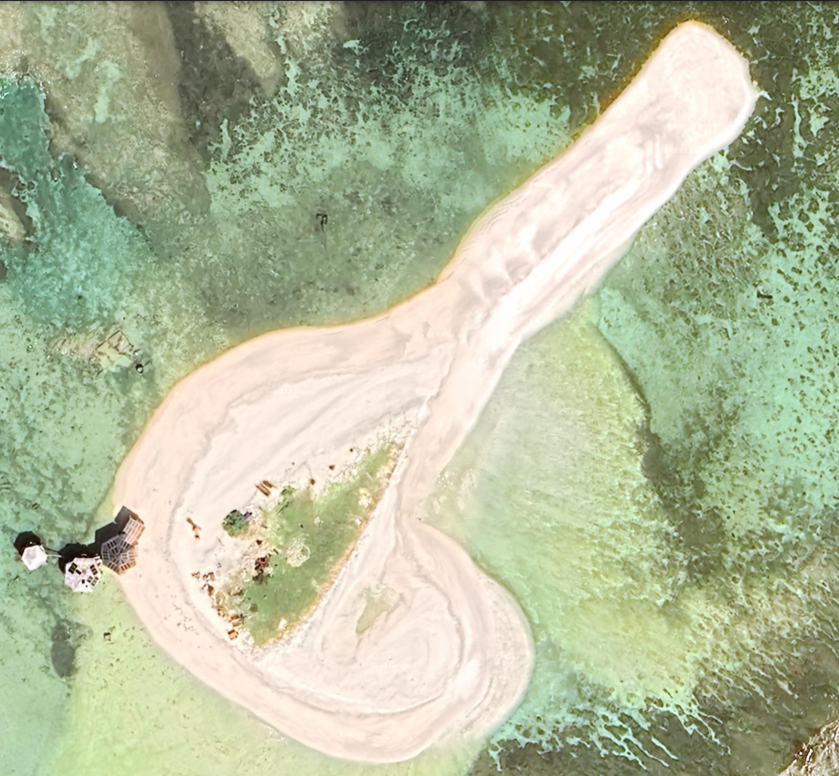
Satellite imagery: 10/19/2023, coordinates: 10°49'01"N 115°49'17"E.

Flat Island, and Nanshan Island are both reclamations on the same atoll which is just north of Jackson Atoll and west of Iroquois Reef. Again, the rest of the atolls, reefs and shoals north and east of Flat and Nanshan Island are unmarked and unoccupied according to Maxar Xpress.
​
According to Wikipedia, the Flat and Nanshan islands are both occupied by Philippine soldiers. We see very recent development and reclamation expanding the size of Flat island, which was only 0.02 miles in diameter. We see one building and a little bit of green growth. There is three-part reclamation hardware on the island, so we expect this island to grow.

The Flat Island is under significant development with the two-part infrastructure, and sand, and development occurring in the center of the island. Location: 10°48'59"N 115°49’21”E. The previous satellite image is dated: 02/04/2021.

Based on low resolution imagery from Copernicus Browser, Sentinel-2 imagery from 7/31/2024, the reclamation of the island has grown, and is now 224 meters long. 


Picture
Flat Island 10/19/2023
Picture
Flat Island 2/4/2021
Nanshan Island, a.k.a. Lawak Island (Philippines)

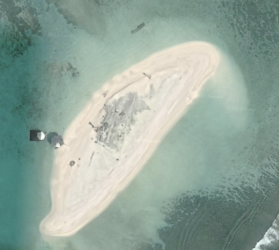
This island is currently being further developed with buildings from 2021 to 2023 as shown in the two satellite images below.
​
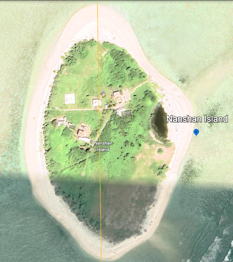
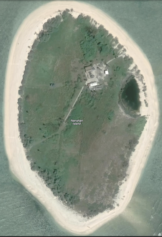
Nanshan Island is also dated 02/04/2021, and is an oval island with sandy undeveloped beaches, one housing and building area, and a path from that location into the center of the island, and to the  beach. There is also a stand-alone structure in the Northwest. Location: 10°43'57"N 115°48’11"E. 

Nanshan Island, or Lawak Island, is claimed by China (PRC), Taiwan (ROC), Vietnam and the Philippines.

These two islands are in the West Philippine Sea. Coordinates: 10°44′N 115°48′E from Wikipedia.

According to Wikipedia, the Philippines claimed these islands in 1968 and stationed a 'handful of soldiers and their families' on both Nanshan Island and Flat Island which is nearby, and has constructed five lighthouses in this area. The islands are administered by the Philippines as part of Kalayaan, Palawan. 

We have new satellite imagery of Nanshan Island that shows at least four new building complexes. Satellite imagery dated 10/19/2023. The diameter of the island is 0.26 miles.

Based on low resolution Sentinel-2 imagery from 7/31/2024, the island looks the same as in 2023.

All of the islands East of Nanshan all the way to Palawan are undeveloped.


To the East of Nanshan is Hopkins Reef, which is completely submerged as of 3/11/2018. 
Picture
Nanshan Island 10/19/2023 from Google Earth
Picture
Nanshan Island 2/4/2021 Source: Google Earth
Iroquois Reef

This is an underwater reef that is east of Nanshan island, and southeast of Hopkins Reef. ​Iriquois Reef, which is large and long, stretching north to south, shaped a bit like a fishing hook, which is also undeveloped and fully submerged. This may be part of the Amy Douglas Bank, which is labeled via Google Earth but with no visible reefs in the satellite imagery.

Iroquois Reef has been gaining attention recently from Chinese fishing vessels, as noted by Philippine Navy reconnaissance patrols. On June 30, 2024, there were 49 visible from the aircraft in Iroquois Reef, which could signal either increased fishing or something more nefarious.

​We share an image of the southern tip of the atoll, location
10°37'46"N 116°10'35"E, satellite imagery: 3/1/2019, shows this as an underwater, but shallow reef with possible reclamation activity (or permanent navigation markets) at the southern tip of the reef.

We confirmed that Iroquois Reef is unreclaimed, and the two infrastructure elements are still in place, via Sentinel-2 L1C, as of 7/31/2024.
Picture
Iroquois Reef, Google Earth, 12/14/2015
Picture
Iroquois Reef, Google Earth, 3/1/2019, southern tip of the atoll.
To the north of Iroquois Reef is Third Thomas Shoal, which is also below sea level and undeveloped. We see more reefs to the east, another fishing hook shape at location10°31'22"N 116°31'17"E, dated 12/14/2015 which are submerged and undeveloped.
Further east at Reed Bank we see another submerged atoll structure, at location 10°59'04"N 116°51'11"E, as of 12/14/2015.
​
The next formation to the East is called Wood Bank, east of a further map notation of Bin Jiao. We can only see the Southern half of the island due to satellite photo issues. It is fully submerged. Location: 10°35'36"N 117°11’05”E.

To the Northeast, we see Leslie Bank at location 11°05'53"N 117°25'37"E, which is fully undeveloped in undated Google Earth satellite imagery. 

Finally, east of Leslie Bank and closest to the Philippines (most East formation) is Seahorse Shoal, location: 10°47'55"N 117°43'54"E, 114.2 miles from the town of Taytay, Palawan, Philippines, which as of Google Earth on 4/25/2019, is also undeveloped. It is shaped like an oval atoll, with contiguous edges.

Jackson Atoll
​South of Nanshan Island we see Jackson Atoll, a large reef structure with five separately identified sections, and none are developed. Location: 10°29'52"N 115°45'03"E. ​This satellite imagery is from 05/27/2020. The five reefs are Dickinson Reef, Petch Reef, Hampson Reef, Deane Reef and Hoare Reef.

We checked Jackson Atoll via Copernicus Browser, Sentinel-2 L2A, and Sentinel-2 L1C, imagery from 7/31/2024, and it remains undeveloped with no signs of island reclamation. Maxar Xpress placed their Philippine 'circle' to include Hoare Reef and Dickinson Reef.
Picture
Livock Reef

South of Jackson Atoll, we find Livock Reef
, location °10'30"N 115°20’49”E-, which is undeveloped. Google earth imagery 3/1/2017.

Hopps Reef
Just east and adjacent to Livock Reef at location
10°15'09"N 115°21'39"E, we see a reef that is also fully submerged, natural, and undeveloped. Google Earth satellite imagery from 3/23/2019.


Copyright 2024 & 2025 US Advanced Computing Infrastructure, Inc., Chicago Quantum (SM)
833 Central Avenue #1292, Highland Park, Illinois 60035-7292
​+1.312.515.7333

  • Home
    • About Us & What We Do
    • Our Capabilities
    • Brochure
    • Positions
  • Projects
    • Quantum Computing >
      • Quantum Computing - What is it?
      • Investing in Quantum Computing Stocks
      • Early Use Cases for Quantum Computing (2019 & 2020)
      • Early Use Case - Detail
      • 2020 Quantum Computing Ecosystem
      • Platforms Detail
      • 2024 Quantum Computing - What we are seeing
      • PQC Post Quantum Cryptography
    • South China Sea >
      • Nearshore Islands >
        • Swallow Reef and multiple reefs near Malaysia
        • Louisa Reef, Brunei
        • Basco and Mavudis Islands, Batanes, Philippines
        • Scarborough Shoal and Second Thomas Shoal, Philippines
        • Laut Island, Indonesia
        • Natuna Island, Indonesia
        • Dao Bach Long, Vietnam, Gulf of Tonkin
        • Koh Paulo Wai, and related islands in Kien Giang Province, Vietnam, Gulf of Thailand
        • Con Dao and Vanguard Bank, Vietnam
        • Long Hai, Vietnam
        • Qizhou Liedao & Nanshi, Hainan, China
        • Dongsha, Pratas Islands, Republic of China
        • Penghu County, Republic of China
        • Kinmen County Islands, Republic of China
        • Southern South China Sea
        • Mengalum, Pulau Tiga and Kampong Mantanani , Malaysia
        • Strategic underwater reef of the coast of mainland China
      • Spratly Islands >
        • Subi Reef, China, Spratly Islands
        • Mischief Reef, Spratly Islands
        • Fiery Cross Reef, Yongshu Jiao, China, Spratly Islands
        • Thitu Island, Pag-asa, Kalayaan, Spratly Islands
        • Taiping Island, Spratly Islands
        • Spratly Island and Ladd Reef Vietnam, Spratly Islands
        • North Danger Reef & Trident Shoal, Spratly Islands
        • Irving Reef, West York and Loaita Bank, Spratly Islands
        • Sand Cay, Namyit Island, and Gaven Reef, Tizard Bank, and Great Discovery Reef, Spratly Islands
        • Union Bank, Johnson South Reef, Sin Cowe, Hughes Reef, Whitsun Reef, Spratly Islands
        • Nanshan Island, Flat Island, Iroquois Reef, Jackson Atoll, Spratly Islands
        • Sabina Shoal, Second Thomas Shoal to Half Moon Shoal, West of Palawan, Spratly Islands
        • Amboyna Cay, Rifleman Bank, Barque Canada Reef, Vietnam
        • Erica Reef, Mariveles Reef, Investigator Island and Viper North, Spratly Islands
        • Pearson, Alison, Cornwallis, and Pigeon Reef, Vietnam Occupied
        • Luconia Breakers, Brunei and Malaysia Coast, Spratly Islands
        • London Reefs, Vietnam and Cuarteron Reef a.k.a. Huayang Island, China, Spratly Islands
      • Paracel Islands, China, PRC Overview, South China Sea >
        • Woody Island and Rocky Island, China, Paracel Islands
        • Triton Island, Zhongjian Dao, China, Paracel Islands
        • North Reef, NW Paracel Islands
        • Tree Island, West Sand, North, Middle, South Islands, and the Three Sisters, Xuande Islands, Amphitrite Group, Paracel Islands
        • Lincoln Island, Bombay Reef and Vuladore Reef, Paracel Islands
        • Duncan, Drummond, Pattle, Money and Antelope islands, Crescent Group, Paracel Islands
      • Participant List
      • Active Conflict Areas
      • Energy Transportation, Resources & Production
      • ROC - Taiwan Environment
    • Yellow Sea Construction
    • Iran Overview >
      • Iranian Energy Export Capabilities
      • Iranian Energy Production Capabilities
      • Iranian Energy Refining Capabilities
      • Iranian Importation of Afghan Opium in 2024
  • Advisory
    • Separately Managed Accounts
    • Pharmacy Retail Trends 2024
    • US Residential Real Estate Economic Analysis
  • Insights