Dongsha, Pratas Islands, Republic of China
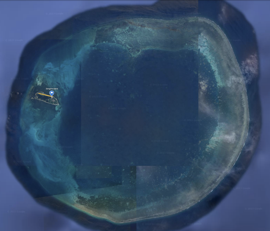
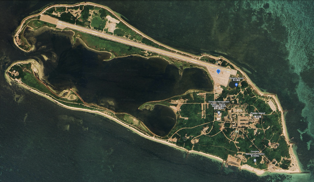
We see a man-made, well developed island on the Pratas Reef that is currently inhabited by Republic of China Marines, and workers for the various marine research, a weather station, and administrative facilities. It is administered out of Kaohsiung, Taiwan.
Pratas Reef is a circular coral atoll 14.8 miles in diameter, and the depth of the lagoon within the reef is up to 16 meters. The west of the reef is submerged and very dangerous for navigation while the north, south and east are steep and visible. This is a fairly dangerous island to approach by ship, especially during rough seas. According to the U.S NGA Sailing Directions (Publication 161) 2020, pages 4,5, it constitutes a danger to vessels transiting the Taiwan Strait.
Thank you Wikipedia for the names.
We see a significant airport, with a 0.93 mile long runway, and a tarmac where one plane was parked when the satellite imagery was taken. We see many buildings, athletic facilities, and many circular man-made installations, potentially cannons and anti-aircraft artillery, located around the island. We do not see any radomes.
The Dongsha island is located here: 20°42'11"N 116°43’24”E, at the 9:30 position (about 280 degrees) in the round Pratas Islands formation. Satellite imagery: 4/23/2023.
The map of the island shows marine research labs, marine management stations, and a significant Dongsha airport. We understand there are numerous oil wells nearby including the Huizhou Offshore Oil Terminal.
Name 1
Nearest Land
Distance from Land (miles)
Location (latitude & longitude)
Diameter (miles)
Date of Satellite Imagery
Airport Present?
Helipad Present?
Port / Dock Facility Present?
Buildings Present?
Defensive Infrastructure Present?
Athletic Facilities Present?
Hospital Present?
Sand Only Island?
Dredging Infrastructure Only?
Western South China Sea (closest to China)
Dongsha Island, Pratas Islands
China
153
20°42'11"N 116°43’24”E
1.7
1/15/2022
Yes
Not Sure
Yes
Yes
Yes
Yes
Not Sure
No
No
Consulting Session for one hour
This is a one-hour meeting, remote or in-person, with Jeffrey Cohen, President of U.S. Advanced Computing Infrastructure, Inc.
- You choose the topic and deliverables.
- You may buy multiple hours to fund a project.
We believe management consulting is pursuing "the art of the possible." These are areas where we believe we may be helpful:
- We will discuss our research into the South China Sea
- We offer traditional IT management consulting services.
- We offer quantum computing consulting
- We offer financial investment analysis of stock portfolios based on our Chicago Quantum Net Score (read more in our published research). Today we run a model that analyzes ~3,000 U.S. listed equities and optimizes both 'long' and 'short' stock portfolios.
- Project and program management.
- Outsourcing advisory.
- We run your business problem on our discrete mathematical models (on our own server equipment using our own solvers).
- We may configure and run your problem on quantum annealing computers from D-Wave Systems Inc.
- We ALWAYS work confidentially, diligently, free of conflict of interest, and bring our best thinking and insights.
We can operate at both the strategic and tactical level depending on client need. This includes business strategy, business problem decomposition, mathematical and data design, algorithm design, and use of quantum and classical solvers. The President has a strategic perspective from ~ 30 years of executive corporate management in IT and professional services, and also rolls up his sleeves and codes when there is a good fit with the problem and his expertise.
Absolute discretion and professionalism is assured.
In closing
If you would prefer to discuss this 1:1 and negotiate a scope of work and level of effort, please contact us at [email protected] or call (312) 515-7333. We will develop a quotation and will invoice for our services.

