Chicago Quantum
  • Home
    • About Us & What We Do
    • Our Capabilities
    • Brochure
    • Positions
  • Projects
    • Quantum Computing >
      • Quantum Computing - What is it?
      • Investing in Quantum Computing Stocks
      • Early Use Cases for Quantum Computing (2019 & 2020)
      • Early Use Case - Detail
      • 2020 Quantum Computing Ecosystem
      • Platforms Detail
      • 2024 Quantum Computing - What we are seeing
      • PQC Post Quantum Cryptography
    • South China Sea >
      • Nearshore Islands >
        • Swallow Reef and multiple reefs near Malaysia
        • Louisa Reef, Brunei
        • Basco and Mavudis Islands, Batanes, Philippines
        • Scarborough Shoal and Second Thomas Shoal, Philippines
        • Laut Island, Indonesia
        • Natuna Island, Indonesia
        • Dao Bach Long, Vietnam, Gulf of Tonkin
        • Koh Paulo Wai, and related islands in Kien Giang Province, Vietnam, Gulf of Thailand
        • Con Dao and Vanguard Bank, Vietnam
        • Long Hai, Vietnam
        • Qizhou Liedao & Nanshi, Hainan, China
        • Dongsha, Pratas Islands, Republic of China
        • Penghu County, Republic of China
        • Kinmen County Islands, Republic of China
        • Southern South China Sea
        • Mengalum, Pulau Tiga and Kampong Mantanani , Malaysia
        • Strategic underwater reef of the coast of mainland China
      • Spratly Islands >
        • Subi Reef, China, Spratly Islands
        • Mischief Reef, Spratly Islands
        • Fiery Cross Reef, Yongshu Jiao, China, Spratly Islands
        • Thitu Island, Pag-asa, Kalayaan, Spratly Islands
        • Taiping Island, Spratly Islands
        • Spratly Island and Ladd Reef Vietnam, Spratly Islands
        • North Danger Reef & Trident Shoal, Spratly Islands
        • Irving Reef, West York and Loaita Bank, Spratly Islands
        • Sand Cay, Namyit Island, and Gaven Reef, Tizard Bank, and Great Discovery Reef, Spratly Islands
        • Union Bank, Johnson South Reef, Sin Cowe, Hughes Reef, Whitsun Reef, Spratly Islands
        • Nanshan Island, Flat Island, Iroquois Reef, Jackson Atoll, Spratly Islands
        • Sabina Shoal, Second Thomas Shoal to Half Moon Shoal, West of Palawan, Spratly Islands
        • Amboyna Cay, Rifleman Bank, Barque Canada Reef, Vietnam
        • Erica Reef, Mariveles Reef, Investigator Island and Viper North, Spratly Islands
        • Pearson, Alison, Cornwallis, and Pigeon Reef, Vietnam Occupied
        • Luconia Breakers, Brunei and Malaysia Coast, Spratly Islands
        • London Reefs, Vietnam and Cuarteron Reef a.k.a. Huayang Island, China, Spratly Islands
      • Paracel Islands, China, PRC Overview, South China Sea >
        • Woody Island and Rocky Island, China, Paracel Islands
        • Triton Island, Zhongjian Dao, China, Paracel Islands
        • North Reef, NW Paracel Islands
        • Tree Island, West Sand, North, Middle, South Islands, and the Three Sisters, Xuande Islands, Amphitrite Group, Paracel Islands
        • Lincoln Island, Bombay Reef and Vuladore Reef, Paracel Islands
        • Duncan, Drummond, Pattle, Money and Antelope islands, Crescent Group, Paracel Islands
      • Participant List
      • Active Conflict Areas
      • Energy Transportation, Resources & Production
      • ROC - Taiwan Environment
    • Yellow Sea Construction
    • Iran Overview >
      • Iranian Energy Export Capabilities
      • Iranian Energy Production Capabilities
      • Iranian Energy Refining Capabilities
      • Iranian Importation of Afghan Opium in 2024
  • Advisory
    • Separately Managed Accounts
    • Pharmacy Retail Trends 2024
    • US Residential Real Estate Economic Analysis
  • Insights

Subi Reef, China, Spratly Islands

Updated May 31, 2025

No Google Earth updates since May 2022.
No visible reclamation / expansion since 2024.
​
Picture
Copernicus Browser, Sentinel-2 300m resolution, Subi Reef True Color. May 26, 2025 imagery.
Updated August 29 2024
Subi Reef, China
Subi Reef is an advanced military island developed, maintained and operated by the People's Republic of China (PRC). This island should be considered in context of being one of three Chinese military islands in the Spratlys in an equilateral triangle, along with Fiery Cross Reef and Mischief Reef. Subi Reef makes up the northern point of that ~120 mile-sided triangle, and is 15 miles Southwest of Thitu Island (Philippine civilian permanently-occupied island).

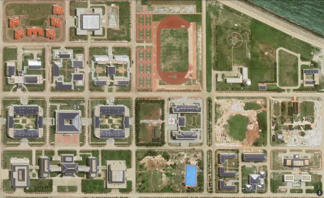
This island is shaped as a "C" around a 3.82 mile diameter coral atoll. The island is 3.45 miles in diameter, with an extensive lagoon. It extends approximately 60% around the outside. It has a significant airport and aircraft facilities. When we see current photographs in the news (not reproduced here), it reminds me of Atlantic City, Macao, or even O'Hare Airport. Dense, modern buildings, lots of construction activity, and airport technologies are visible.  There are four navigation lights demarking the channel into the reef.

The single island is in the shape of a C or an open mouth, with an overbite. This is different than the development of other atolls, where they fill in the center.

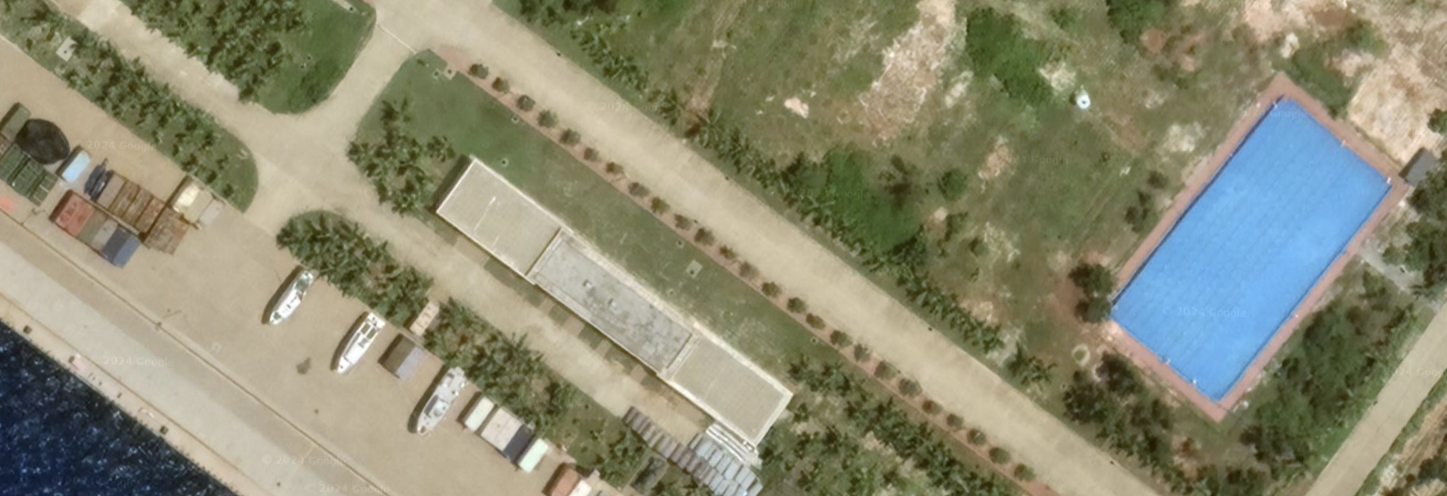
There is a well defined channel carved into the Reef to the south allowing fishing and naval access to the lagoon. We see four boats in the lagoon and one boat along the port dock. Location: 0°54'23"N 114°07’51”E.  Satellite Imagery for the center of the island, ending at the tip of the bottom of the "C", is 5/10/2022. The Western portion of the island is 5/16/2022.

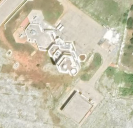
At the tip of the bottom of the "C", we see a significant AA Cannon emplacement with at least two cannons, and possibly more. We also a different structure. Missile launchers with retractable covers. These are elevated, and look to be the height of a one to two story building. They have the 'tell-tale' sliding roof that takes up half the space, this time in a uniform standard white, and they are located at the very tip of the bottom "C" at the furthest point on the island. Eight missile launch pods on the bottom of Subi Reef Island.

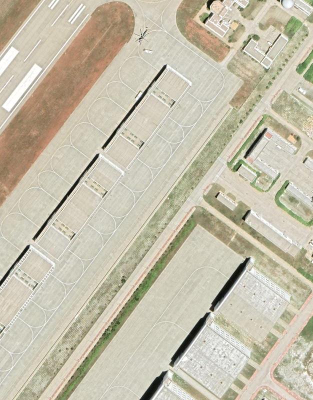
I am also amazed with the number of hangars connected to the runway that seem to be made of concrete, and could store aircraft. There are at least 24 at the southern end of the runway. From a distance, this is a well laid out island fortress, with living quarters to the North, and aircraft hangers and other military equipment to the south.

Subi Reef is located 14 miles west of Thitu, which is the one Philippine strategic island in the Spratlys.
​
This is a fully militarized island, according to U.S. Admiral John C. Aquilino, in a Reuters news interview given during a tour of the Spratly Islands in a U.S. Navy reconnaissance aircraft that flew near these features, and was published March 21, 2022. According to U.S. Admiral Aquilino, Subi Reef, Mischief Reef and Fiery Cross are fully militarized islands occupied by PRC China.
Picture
Subi Island, 5/10/2022 and 5/16/2023. Google Earth Camera 7,865m 0m.
Picture
Picture
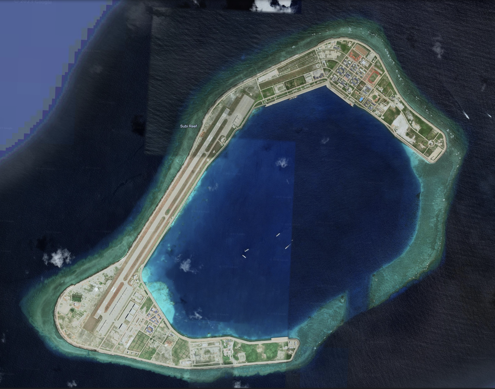
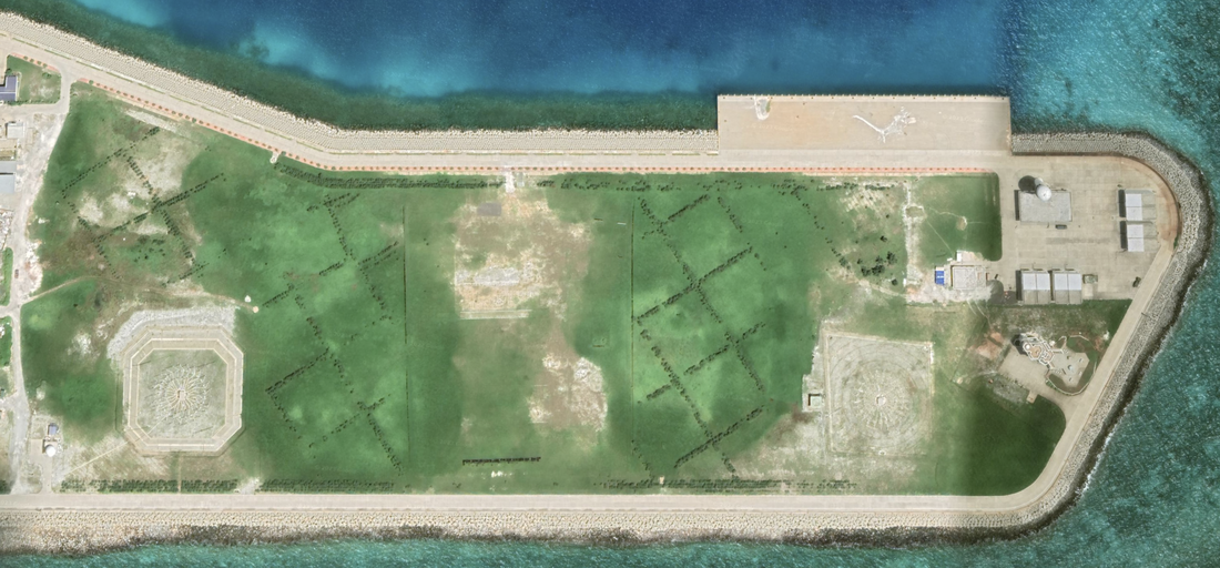
Eight Subi Reef Island Missile Launchers with some AA Cannons at the bottom of the island's "C" May 10, 2022
Picture
Subi Reef runway is 1.95 miles long with aircraft parking at either end. We will rotate the image for the next few discussion points. We see 28 aircraft hangars, with 20 of them being smaller than the 8 that appear much larger. We also see many of the white radomes on towers, and we see another cannon building on the Southern end of the airfield, as seen here, and another at the other end by base housing. We also see a helicopter.

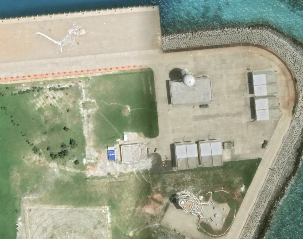
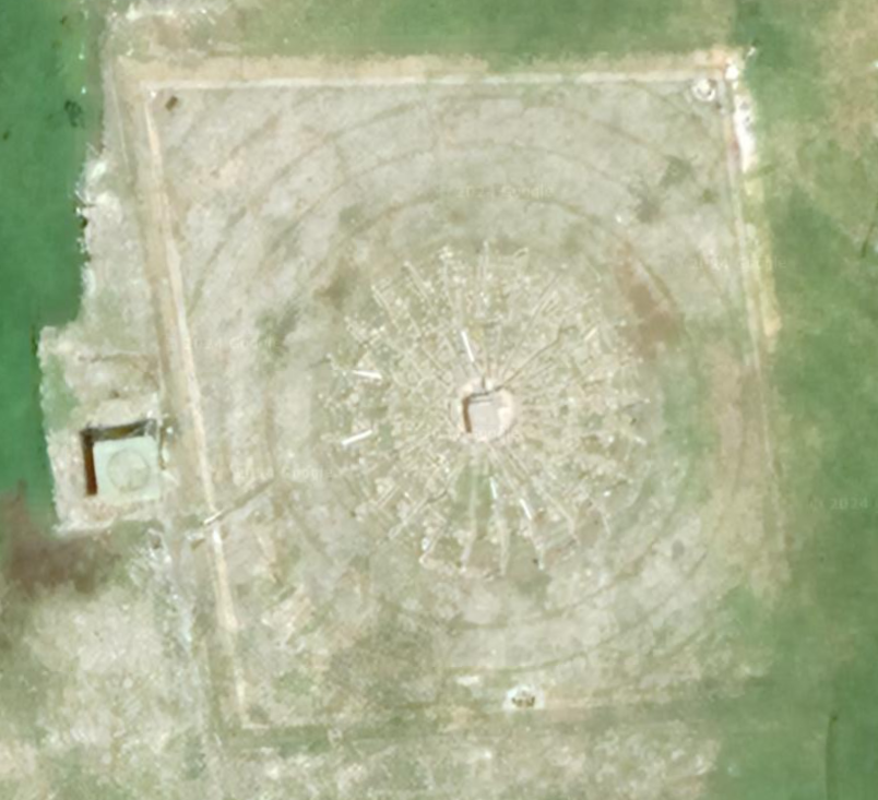
At the bottom of the C, at the entrance to the bay, we see a pair of white radomes on towers, a common white / gray building structure we have seen before on many islands with at least one cannon on the roof (the cannon building - image on left).  The structure of the building below, what we call the cannon building, is similar and we have seen it on other islands in the South China Sea.

We see a strange formation set into the ground, with a rectangle etched with concentric circles, a small rectangular box in the center, and one to the left. This is the first time I have seen this and it looks important. Image on right.

Picture
Picture
At the Northern end of Subi Reef we see base housing, two hospital facilities, and some communication towers. We see a mandarin character in the grass just East of the running track and ten basketball / soccer courts.
​
Picture
We have seen something like this blue rectangle, which appears to be almost at ground level, and close to the water. Not sure what it is...but it is on one of the other fortified PRC islands near a pier.
Picture
Area
Name 1
Nearest Land
Distance from Land (miles)
Location (latitude & longitude)
Diameter (miles)
Date of Satellite Imagery
Airport Present?
Helipad Present?
Port / Dock Facility Present?
Buildings Present?
Defensive Infrastructure Present?
Athletic Facilities Present?
Hospital Present?
Sand Only Island?
Dredging Infrastructure Only?


Spratly Islands
Subi Reef
Philippines and Vietnam
314 and 318
0°54'23"N 114°07’51”E
3.45
5/19/2022
Yes
Yes
Yes
Yes
Yes
Yes
Yes
No
No

​

Copyright 2024 & 2025 US Advanced Computing Infrastructure, Inc., Chicago Quantum (SM)
833 Central Avenue #1292, Highland Park, Illinois 60035-7292
​+1.312.515.7333

  • Home
    • About Us & What We Do
    • Our Capabilities
    • Brochure
    • Positions
  • Projects
    • Quantum Computing >
      • Quantum Computing - What is it?
      • Investing in Quantum Computing Stocks
      • Early Use Cases for Quantum Computing (2019 & 2020)
      • Early Use Case - Detail
      • 2020 Quantum Computing Ecosystem
      • Platforms Detail
      • 2024 Quantum Computing - What we are seeing
      • PQC Post Quantum Cryptography
    • South China Sea >
      • Nearshore Islands >
        • Swallow Reef and multiple reefs near Malaysia
        • Louisa Reef, Brunei
        • Basco and Mavudis Islands, Batanes, Philippines
        • Scarborough Shoal and Second Thomas Shoal, Philippines
        • Laut Island, Indonesia
        • Natuna Island, Indonesia
        • Dao Bach Long, Vietnam, Gulf of Tonkin
        • Koh Paulo Wai, and related islands in Kien Giang Province, Vietnam, Gulf of Thailand
        • Con Dao and Vanguard Bank, Vietnam
        • Long Hai, Vietnam
        • Qizhou Liedao & Nanshi, Hainan, China
        • Dongsha, Pratas Islands, Republic of China
        • Penghu County, Republic of China
        • Kinmen County Islands, Republic of China
        • Southern South China Sea
        • Mengalum, Pulau Tiga and Kampong Mantanani , Malaysia
        • Strategic underwater reef of the coast of mainland China
      • Spratly Islands >
        • Subi Reef, China, Spratly Islands
        • Mischief Reef, Spratly Islands
        • Fiery Cross Reef, Yongshu Jiao, China, Spratly Islands
        • Thitu Island, Pag-asa, Kalayaan, Spratly Islands
        • Taiping Island, Spratly Islands
        • Spratly Island and Ladd Reef Vietnam, Spratly Islands
        • North Danger Reef & Trident Shoal, Spratly Islands
        • Irving Reef, West York and Loaita Bank, Spratly Islands
        • Sand Cay, Namyit Island, and Gaven Reef, Tizard Bank, and Great Discovery Reef, Spratly Islands
        • Union Bank, Johnson South Reef, Sin Cowe, Hughes Reef, Whitsun Reef, Spratly Islands
        • Nanshan Island, Flat Island, Iroquois Reef, Jackson Atoll, Spratly Islands
        • Sabina Shoal, Second Thomas Shoal to Half Moon Shoal, West of Palawan, Spratly Islands
        • Amboyna Cay, Rifleman Bank, Barque Canada Reef, Vietnam
        • Erica Reef, Mariveles Reef, Investigator Island and Viper North, Spratly Islands
        • Pearson, Alison, Cornwallis, and Pigeon Reef, Vietnam Occupied
        • Luconia Breakers, Brunei and Malaysia Coast, Spratly Islands
        • London Reefs, Vietnam and Cuarteron Reef a.k.a. Huayang Island, China, Spratly Islands
      • Paracel Islands, China, PRC Overview, South China Sea >
        • Woody Island and Rocky Island, China, Paracel Islands
        • Triton Island, Zhongjian Dao, China, Paracel Islands
        • North Reef, NW Paracel Islands
        • Tree Island, West Sand, North, Middle, South Islands, and the Three Sisters, Xuande Islands, Amphitrite Group, Paracel Islands
        • Lincoln Island, Bombay Reef and Vuladore Reef, Paracel Islands
        • Duncan, Drummond, Pattle, Money and Antelope islands, Crescent Group, Paracel Islands
      • Participant List
      • Active Conflict Areas
      • Energy Transportation, Resources & Production
      • ROC - Taiwan Environment
    • Yellow Sea Construction
    • Iran Overview >
      • Iranian Energy Export Capabilities
      • Iranian Energy Production Capabilities
      • Iranian Energy Refining Capabilities
      • Iranian Importation of Afghan Opium in 2024
  • Advisory
    • Separately Managed Accounts
    • Pharmacy Retail Trends 2024
    • US Residential Real Estate Economic Analysis
  • Insights