Thitu Islands, Spratly Islands
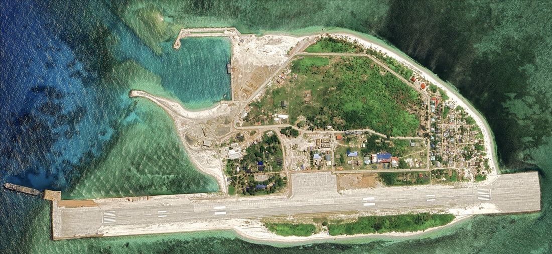
This could be a supply island, and we see a ship on the Western edge docked at a small rectangular port (pointed in and tied down). The runway measures 0.65 miles.
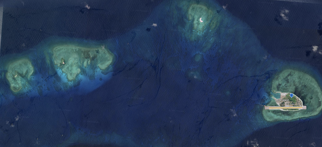
The three early-stage reclamations to the West of Thitu Island indicate future plans for reclamation work. We see three visible reclamations (sand only) to the West of Thitu Island, and ships in the lagoon. Satellite Imagery date: 6/19/2023 Location: 11°04'27"N 114°13’27"E. We took a second reading of the location: 11°03'08"N 114°16'56"E
It reminds me of Subi island, where multiple shoals are connected to form a longer, and in our opinion more useful island structure.
Eastern Reef is to the East of Thitu Reef, and is underwater and has no apparent man-made reclamations.
According to Reuters on December 21, 2023:
"MARCH 4 - The Philippines spots a Chinese navy ship and 42 vessels believed to be manned by Chinese maritime militia personnel in the vicinity of Thitu island, Manila's biggest and most strategically important outpost in the South China Sea."
OCT 16 - The Philippine military says a Chinese navy ship shadowed and attempted to cut off a Philippine navy vessel conducting a resupply mission near Thitu island.
Name 1
Nearest Land
Distance from Land (miles)
Location (latitude & longitude)
Diameter (miles)
Date of Satellite Imagery
Airport Present?
Helipad Present?
Port / Dock Facility Present?
Buildings Present?
Defensive Infrastructure Present?
Athletic Facilities Present?
Hospital Present?
Sand Only Island?
Dredging Infrastructure Only?
Spratly Islands
Thitu Reef
Philippines and Vietnam
314 and 318
11°04'27"N 114°13’27"E
0.83
6/19/2023
Yes
No
Yes
Yes
Yes
No
No
No
No
Consulting Session for one hour
This is a one-hour meeting, remote or in-person, with Jeffrey Cohen, President of U.S. Advanced Computing Infrastructure, Inc.
- You choose the topic and deliverables.
- You may buy multiple hours to fund a project.
We believe management consulting is pursuing "the art of the possible." These are areas where we believe we may be helpful:
- We will discuss our research into the South China Sea
- We offer traditional IT management consulting services.
- We offer quantum computing consulting
- We offer financial investment analysis of stock portfolios based on our Chicago Quantum Net Score (read more in our published research). Today we run a model that analyzes ~3,000 U.S. listed equities and optimizes both 'long' and 'short' stock portfolios.
- Project and program management.
- Outsourcing advisory.
- We run your business problem on our discrete mathematical models (on our own server equipment using our own solvers).
- We may configure and run your problem on quantum annealing computers from D-Wave Systems Inc.
- We ALWAYS work confidentially, diligently, free of conflict of interest, and bring our best thinking and insights.
We can operate at both the strategic and tactical level depending on client need. This includes business strategy, business problem decomposition, mathematical and data design, algorithm design, and use of quantum and classical solvers. The President has a strategic perspective from ~ 30 years of executive corporate management in IT and professional services, and also rolls up his sleeves and codes when there is a good fit with the problem and his expertise.
Absolute discretion and professionalism is assured.
In closing
If you would prefer to discuss this 1:1 and negotiate a scope of work and level of effort, please contact us at [email protected] or call (312) 515-7333. We will develop a quotation and will invoice for our services.