Paracel Islands Overview, South China Sea
Paracel Islands, also known as Xisha Islands, 西沙群島, or Xisha Qundao or Western Sand Archipelago in China, as Hoang Sa Archipelago or Quần đảo Hoàng Sa, or Yellow Sand Archipelago in Vietnamese (thank you Wikipedia). These features are largely divided into the Amphitrite group in the Northeast (e.g., Woody Island), and the Crescent group in the West (e.g., Prattle Island) (ty Britannica).
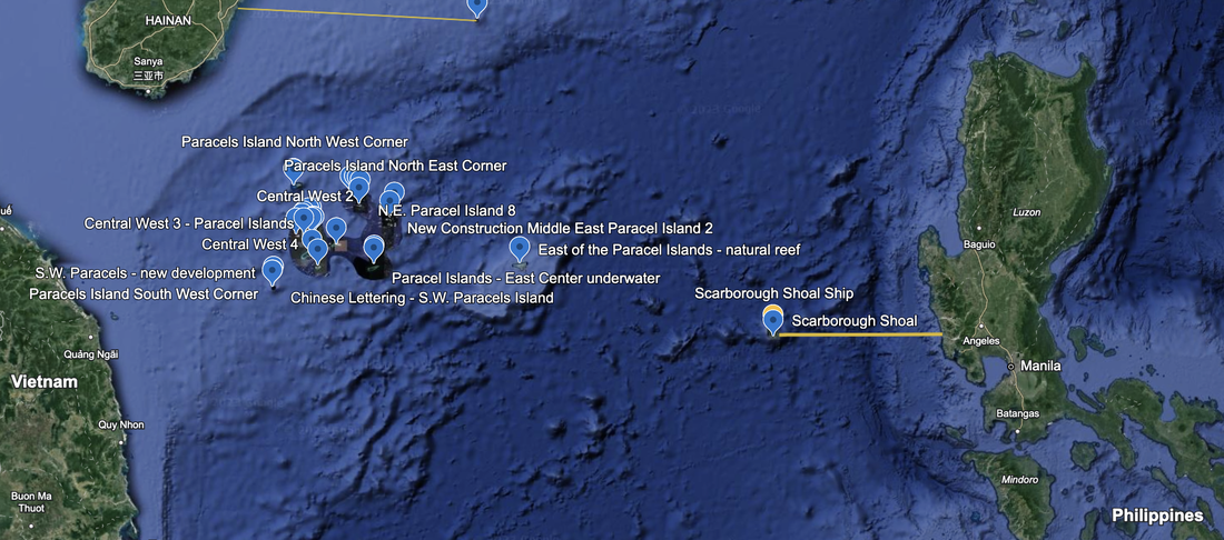
These are the six island or reef groupings in the Paracels that we document on individual webpages.
These features are under the de-facto control of PRC since the Battle of the Paracel Islands in January, 1974 when the PRC expelled Vietnamese forces from the Crescent Group. The battle is called: "In Chinese, the brief battle is known as the “Self-Defense War of Xisha” (西沙自卫反击战), as opposed to Vietnamese name, the Naval Battle of Hoàng Sa (Hải chiến Hoàng Sa)." Woody Island, which now has a permanent population of 1,000 people (thank you The Diplomat dot com), is the capital of the administrative unit Sansha City, Hainan Province, which oversees all PRC interests in the South China Sea.
These islands are claimed by 'de jure' sovereignty by PRC, Vietnam and ROC.
In 2020, we saved a military notice by PRC that outlined this area: HN0059 SOUTH CHINA SEA, MILITARY EXERCISES IN AREA BOUNDED BY THE LINES JOINING:
A:17-16.12N/111-24.65E; B:18-02.19N/112-59.45E; C:16-58.63N/113-48.37E;
D:16-29.12N/113-44.93E; E:15-41.19N/112-38.17E; F:16-03.58N/111-26.69E.
FROM 301600UTC JUN. TO 051600UTC JUL, ENTERING PROHIBITED. HAINAN MSA CHINA.
This is a very busy and crowded portion of the South China Sea. the Northwest corner is 132 miles from Hainan, China. The Southwest corner is 156 miles from Quang Ngai, Vietnam. The easternmost reef is 355 miles from the Philippines.
Google Earth shows numerous reefs, navigation aids, reclamation equipment, and developed islands in this island grouping.
We created one webpage for each section of the Paracel Islands which can be navigated to from this page in the dropdown menu.
These reefs, shoals, atolls, and islands generally do not have names in Google Earth. Therefore, we are using directional names like Central West #x or Northeast #y. In the future, we may go back and fill in names in English and local languages as we learn more about these islands (e.g., Pattle Island in the Crescent Group and Woody Island in the Amphitrite Group). We may also mark the Dragon Hold, a deep underwater sinkhole.
The economy of the Paracels is fishing, and potentially oil and gas reserves.
Wikipedia gives a brief history of the Paracels:
16th century: Portuguese
20th century (1930s): French Indochina set up installations on Pattle Island (Crescent Group) and Woody Island (Boisee in French) which were kept supplied until 1945.
World War II: Japanese Troops established a presence on the Paracel Islands during the Second Sino-Japanese War.
1946: PRC established a garrison on Woody Island.
January 1947: French and Vietnamese forced landed on Pattle Island, and by 1955, South Vietnam possessed the Crescent Group.
1956: PRC established permanent presence on Woody Island (fishing island before then)
1974: PRC expelled the South Vietnamese from the Crescent Group and took full control of the Paracel Islands.
Paracel Island - Xisha Archipelago Tourism
In recent days, China has cruise ship trips that depart Sanya, Hainan, China for Xisha Islands. Cruise ship tourism started in 2013, and after a stop for Covid 19, has resumed. Two ships were named in a Xinhuanet.com article, the Nanhai Dream and the Changle Gongzhu (Princess Changle). These ships sail to Yinyu Island and Quanfu Island, and have a capacity of 721 and 466 passengers respectively.
Trip.com has listings in their travel guide, with videos, for Destinations in Hainan, Sansha for Woody Island, and other islands in the Paracels. Here is the Sansha travel guide for trip.com.
In May 2014, the PRC placed an oil rig in the Paracel Islands. This deserves further research as to whether it is still there, whether it discovered an economically viable field, and whether production has occurred.