Overview of the Spratly Islands
The Spratly Islands, a.k.a., Nansha, Truong Sa, Kalayaan, and Kepulauan Islands, are a great collection of natural reefs, shoals and atolls, with numerous man-made islands. A few strategic, developed islands with visible military and/or civilian infrastructure stand out, and we have a webpage on each of them that you navigate to through the drop-down menus.
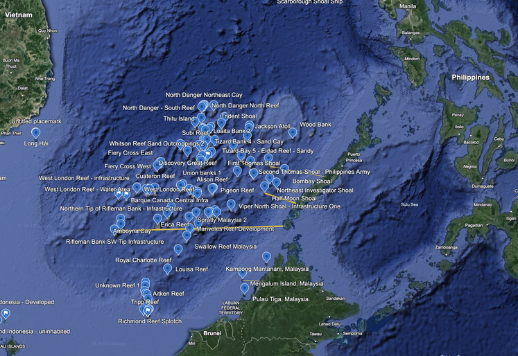
China has three militarized islands in an equilateral triangle, while the Philippines, Vietnam, Malaysia and Taiwan each have one militarized island. We also see continued land reclamation and development continuing throughout.
China has three militarized islands in an equilateral triangle, while the Philippines, Vietnam, Malaysia and Taiwan each have one militarized island. We also see continued land reclamation and development continuing throughout.
We have created seventeen (17) separate web-pages to document the Spratly Islands. You can select the buttons below, or use the drop-down menu for navigation. The countries which occupy each formation are documented in each webpage.
To give a general idea of size, the Spratly islands stretch 451 miles North to South, and 426 miles East to West, or roughly 19,250 square miles. In terms of an American comparison, is roughly the size of Lake Michigan, Lake Superior and Lake Huron (three of the U.S. Great Lakes) combined. It is roughly the size of Kansas and Nebraska combined.
In terms of density, now imagine around 100 villages or towns of approximately one mile in diameter, with some densely populated and others with maybe only a dozen buildings, spread across Kansas and Nebraska.
These islands are densely packed together between Vietnam to the West, Indonesia to the South, Malaysia and Brunei to the Southeast and Southwest, and the Philippines to the East, Cambodia a little farther West and to the North is China, Taiwan and Japan.
We notice a few things before we get into the detailed webpages:
- China (PRC) and the Philippines are having conflicts near the Second Thomas Shoal and Scarborough Shoal where the PRC are bring in numerous ships (civilian, merchant fleet and naval) and confronting the Philippines naval troops operating in those areas. There have been reports of water cannon firing, jostling, bumping that can prevent resupply of Philippine troops and some ship damage. However, there have not been recent military conflicts like there were between Vietnam and PRC in 1974 in the Paracels and later in the Spratly Islands.
- The islands closest to the Philippines are the least developed and are the closest to their underwater, natural state. However, the developed islands come pretty close to the Philippines. Closer than we expected.
- Malaysia has significant developments. We smile when we think of the satellite imagery of the runway with bold letters spelling out Malaysia. Just in case somebody forgot who owned that island.
- Some of the islands are like Barbie dolls. All the curves are to maximum effect because they were built that way. There are long docks, long runways, massive bays, big balls (radomes), and significant man-made developments on some of these islands.
Given time, I would expect sand and land to appear around these structures and for them to grow larger with time. Likely it is less costly to perform land reclamation once there is a core island. Most islands seems to take up less than 50% of the underlying coral reef, and present room to grow. In a few cases the reclamation covers 95% or more of the diameter of the island.
- We have seen dozens of what we call reclamation infrastructure posts on the reefs across the area. These are collections of one, two or three significant pieces of infrastructure, connected by a walkway or bridge, that we believe are used to dredge up sand from the ocean floor and create land. They have very consistent shapes, but at this point we cannot say how they work. We have seen one where the sand seems to be pouring out of them, but the rest appear to be anchored in deep water. We sometimes see them adjacent to navigation channels cut into the reefs.
- These reefs, shoals, atolls, and islands generally have names in Google Earth, and we use those English names wherever possible. In the future, we may go back and fill in names in other languages.
We will create one webpage for each grouping of islands.
We are starting at the Northwest corner of the island grouping, and working our way south to the Southwest.
We are developing insights along the way, and would be glad to share them with clients.
We identify and describe each man-made island that we find through Google Earth, Wikipedia, US Navy publications, and the occasional detail from other open sources of intelligence.
According to Encyclopedia Britannica, here, the French held them between 1933 and 1939, followed by the Japanese who renounced their ownership in 1951. After that, ROC, PRC, Vietnam and Philippines all claimed ownership. In the 1970s, South Vietnam occupied islands, along with Taiwan (Itu Aba), and the Philippines moved forces onto seven islands and built an airstrip in 1976 on Pagasa Island. Initially, all claimants had garrisons on islands except for PRC, and of note is that the United States does not recognize any of the claims, and considers the Spratly Islands as international waters.
According to The Diplomat Dot Com, here, Vietnam and PRC had a battle in the Spratly Islands where over 60 Vietnamese soldiers were killed and three Vietnamese Naval Vessels were sunk. The battle took place near the Johnson South Reef.
According to historian and Vietnamese Citizen Andre Menras, in the film “Hoang Sa Vietnam: La Meurtrissure” (“Hoang Sa Vietnam: Painful Loss”), he documents the conflict between Vietnamese fishermen, the PLAN, and the Chinese merchant marine fleet, although there is another point of view given Vietnam's aggressive and increasingly global fishing industry, as read here.
According to historian and Vietnamese Citizen Andre Menras, in the film “Hoang Sa Vietnam: La Meurtrissure” (“Hoang Sa Vietnam: Painful Loss”), he documents the conflict between Vietnamese fishermen, the PLAN, and the Chinese merchant marine fleet, although there is another point of view given Vietnam's aggressive and increasingly global fishing industry, as read here.
According to Al Jazeera reporting in 2012, the Spratly Islands contain hydrocarbon deposits valued at $26.3 Trillion in 2012 dollars in an article titled Standoff at Scarborough Shoal. "The Scarborough Shoal has valuable resources including fishing, shipping routes and potentially enormous oil and gas deposits. " We will have to look further into those oil and gas reserves.
According to a November 17, 2023 Reuters report, Vietnam has dramatically increased its land reclamation work in the Spratly Islands creating 330 acres of land since December 2022, or in the past 11 months. This compares to the creation of 120 acres for the prior 10 years from 2012 to 2022.
China has South China Sea outposts in the South China Sea capable of supporting military operations, according to a U.S. DoD unclassified report by the Office of the Secretary of Defense to Congress (Military and Security Developments Involving the People’s Republic of China , 2023, the Annual Report) where they state (verbatim):
Since early 2018, the PRC-occupied Spratly Islands outposts have been equipped with advanced anti-ship and anti-aircraft missile systems and military jamming equipment, representing the most capable land-based weapons systems deployed by any claimant in the disputed SCS areas to date. In mid-2021, the PLA deployed an intelligence-gathering ship and a surveillance aircraft to the Spratly Islands during U.S.-Australia bilateral operations in the region. From early 2018 through 2022, the PRC regularly used its Spratly Islands outposts to support naval and coast guard operations in the SCS. The PRC has added more than 3,200 acres of land to the seven features it occupies in the Spratlys. China has also added military infrastructure, including 72 aircraft hangars, docks, satellite communication equipment, antenna array, radars, and hardened shelters for missile platforms.
China also has a strategy to deny the United States access to the East and South China Seas, as stated (verbatim):
The PRC’s counter-intervention strategy aims to restrict the United States from having a presence in the East and South China Sea regions—within the First Island Chain (FIC)—and increasingly to hold at risk U.S. access in the broader Indo-Pacific region.